You are here: Home > Network List > N4 - Central and EAstern US Network Stations List
> Station N38B Corydon, IA, USA > Earthquake Result Viewer
N38B Corydon, IA, USA - Earthquake Result Viewer
| Earthquake location: |
Turkey |
| Earthquake latitude/longitude: |
38.0/37.2 |
| Earthquake time(UTC): |
2023/02/06 (037) 10:24:49 GMT |
| Earthquake Depth: |
10 km |
| Earthquake Magnitude: |
7.5 mww |
| Earthquake Catalog/Contributor: |
NEIC PDE/us |
|
| Network: |
N4 Central and EAstern US Network |
| Station: |
N38B Corydon, IA, USA |
| Lat/Lon: |
40.79 N/93.24 W |
| Elevation: |
322 m |
|
| Distance: |
89.4 deg |
| Az: |
324.697 deg |
| Baz: |
36.95 deg |
| Ray Param: |
0.041873608 |
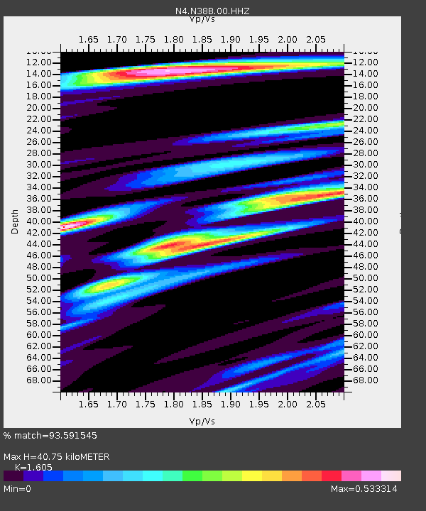
| Estimated Moho Depth: |
40.75 km |
| Estimated Crust Vp/Vs: |
1.61 |
| Assumed Crust Vp: |
6.498 km/s |
| Estimated Crust Vs: |
4.048 km/s |
| Estimated Crust Poisson's Ratio: |
0.18 |
|
| Radial Match: |
93.591545 % |
| Radial Bump: |
400 |
| Transverse Match: |
82.45349 % |
| Transverse Bump: |
400 |
| SOD ConfigId: |
29823551 |
| Insert Time: |
2023-02-20 10:44:04.387 +0000 |
| GWidth: |
2.5 |
| Max Bumps: |
400 |
| Tol: |
0.001 |
|

Signal To Noise
| Channel | StoN | STA | LTA |
| N4:N38B:00:HHZ:20230206T10:37:14.539982Z | 8.766411 | 4.26141E-6 | 4.8610656E-7 |
| N4:N38B:00:HH1:20230206T10:37:14.539982Z | 4.113815 | 1.6438628E-6 | 3.9959573E-7 |
| N4:N38B:00:HH2:20230206T10:37:14.539982Z | 2.6495874 | 1.1343993E-6 | 4.2814185E-7 |
| Arrivals |
| Ps | 3.9 SECOND |
| PpPs | 16 SECOND |
| PsPs/PpSs | 20 SECOND |


