You are here: Home > Network List > N4 - Central and EAstern US Network Stations List
> Station Z47B Carrollton, AL, USA > Earthquake Result Viewer
Z47B Carrollton, AL, USA - Earthquake Result Viewer
| Earthquake location: |
Turkey |
| Earthquake latitude/longitude: |
38.0/37.2 |
| Earthquake time(UTC): |
2023/02/06 (037) 10:24:49 GMT |
| Earthquake Depth: |
10 km |
| Earthquake Magnitude: |
7.5 mww |
| Earthquake Catalog/Contributor: |
NEIC PDE/us |
|
| Network: |
N4 Central and EAstern US Network |
| Station: |
Z47B Carrollton, AL, USA |
| Lat/Lon: |
33.20 N/88.07 W |
| Elevation: |
64 m |
|
| Distance: |
92.8 deg |
| Az: |
316.739 deg |
| Baz: |
40.205 deg |
| Ray Param: |
0.04140189 |
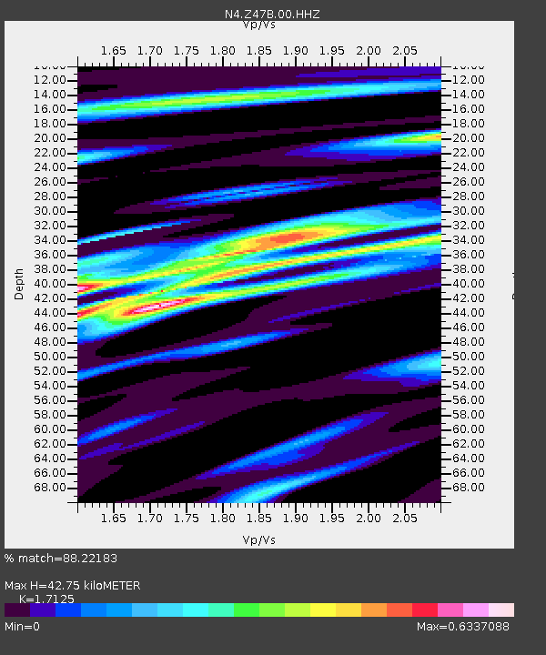
| Estimated Moho Depth: |
42.75 km |
| Estimated Crust Vp/Vs: |
1.71 |
| Assumed Crust Vp: |
6.201 km/s |
| Estimated Crust Vs: |
3.621 km/s |
| Estimated Crust Poisson's Ratio: |
0.24 |
|
| Radial Match: |
88.22183 % |
| Radial Bump: |
400 |
| Transverse Match: |
62.055775 % |
| Transverse Bump: |
400 |
| SOD ConfigId: |
29823551 |
| Insert Time: |
2023-02-20 10:45:51.377 +0000 |
| GWidth: |
2.5 |
| Max Bumps: |
400 |
| Tol: |
0.001 |
|

Signal To Noise
| Channel | StoN | STA | LTA |
| N4:Z47B:00:HHZ:20230206T10:37:30.000004Z | 5.5197473 | 2.5864424E-6 | 4.6857983E-7 |
| N4:Z47B:00:HH1:20230206T10:37:30.000004Z | 1.7921575 | 7.35575E-7 | 4.1044106E-7 |
| N4:Z47B:00:HH2:20230206T10:37:30.000004Z | 1.3137302 | 6.4287315E-7 | 4.893494E-7 |
| Arrivals |
| Ps | 5.0 SECOND |
| PpPs | 18 SECOND |
| PsPs/PpSs | 23 SECOND |


