You are here: Home > Network List > O2 - Oklahoma Consolidated Temporary Seismic Networks Stations List
> Station FW02 Waynoka, Oklahoma, USA > Earthquake Result Viewer
FW02 Waynoka, Oklahoma, USA - Earthquake Result Viewer
| Earthquake location: |
Turkey |
| Earthquake latitude/longitude: |
38.0/37.2 |
| Earthquake time(UTC): |
2023/02/06 (037) 10:24:49 GMT |
| Earthquake Depth: |
10 km |
| Earthquake Magnitude: |
7.5 mww |
| Earthquake Catalog/Contributor: |
NEIC PDE/us |
|
| Network: |
O2 Oklahoma Consolidated Temporary Seismic Networks |
| Station: |
FW02 Waynoka, Oklahoma, USA |
| Lat/Lon: |
36.38 N/98.73 W |
| Elevation: |
434 m |
|
| Distance: |
95.5 deg |
| Az: |
325.676 deg |
| Baz: |
33.492 deg |
| Ray Param: |
0.040778857 |
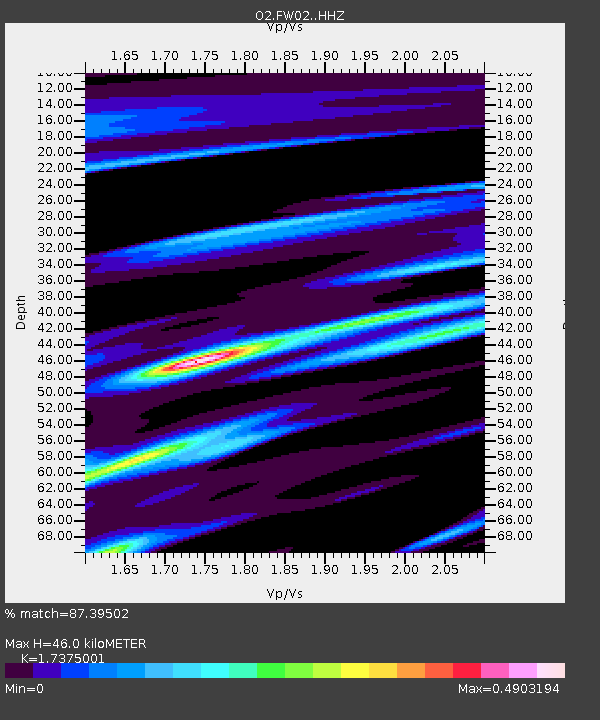
| Estimated Moho Depth: |
46.0 km |
| Estimated Crust Vp/Vs: |
1.74 |
| Assumed Crust Vp: |
6.426 km/s |
| Estimated Crust Vs: |
3.698 km/s |
| Estimated Crust Poisson's Ratio: |
0.25 |
|
| Radial Match: |
87.39502 % |
| Radial Bump: |
284 |
| Transverse Match: |
87.395 % |
| Transverse Bump: |
284 |
| SOD ConfigId: |
29823551 |
| Insert Time: |
2023-02-20 10:47:27.446 +0000 |
| GWidth: |
2.5 |
| Max Bumps: |
400 |
| Tol: |
0.001 |
|

Signal To Noise
| Channel | StoN | STA | LTA |
| O2:FW02: :HHZ:20230206T10:37:42.479985Z | 7.92115 | 1.8099145E-6 | 2.2849137E-7 |
| O2:FW02: :HHN:20230206T10:37:42.479985Z | 2.0861764 | 7.2900997E-7 | 3.4944793E-7 |
| $trig.getChannelId() | $trig.getValue() | $trig.getSTA() | $trig.getLTA() |
| Arrivals |
| Ps | 5.4 SECOND |
| PpPs | 19 SECOND |
| PsPs/PpSs | 25 SECOND |


