You are here: Home > Network List > O2 - Oklahoma Consolidated Temporary Seismic Networks Stations List
> Station SC03 Ninnekah, Oklahoma, USA > Earthquake Result Viewer
SC03 Ninnekah, Oklahoma, USA - Earthquake Result Viewer
| Earthquake location: |
Turkey |
| Earthquake latitude/longitude: |
38.0/37.2 |
| Earthquake time(UTC): |
2023/02/06 (037) 10:24:49 GMT |
| Earthquake Depth: |
10 km |
| Earthquake Magnitude: |
7.5 mww |
| Earthquake Catalog/Contributor: |
NEIC PDE/us |
|
| Network: |
O2 Oklahoma Consolidated Temporary Seismic Networks |
| Station: |
SC03 Ninnekah, Oklahoma, USA |
| Lat/Lon: |
34.94 N/97.85 W |
| Elevation: |
349 m |
|
| Distance: |
96.3 deg |
| Az: |
324.274 deg |
| Baz: |
34.147 deg |
| Ray Param: |
0.040560022 |
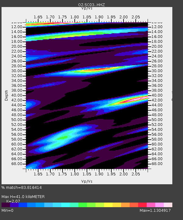
| Estimated Moho Depth: |
41.0 km |
| Estimated Crust Vp/Vs: |
2.07 |
| Assumed Crust Vp: |
6.426 km/s |
| Estimated Crust Vs: |
3.104 km/s |
| Estimated Crust Poisson's Ratio: |
0.35 |
|
| Radial Match: |
83.816414 % |
| Radial Bump: |
379 |
| Transverse Match: |
68.3826 % |
| Transverse Bump: |
400 |
| SOD ConfigId: |
29823551 |
| Insert Time: |
2023-02-20 10:48:13.757 +0000 |
| GWidth: |
2.5 |
| Max Bumps: |
400 |
| Tol: |
0.001 |
|

Signal To Noise
| Channel | StoN | STA | LTA |
| O2:SC03: :HHZ:20230206T10:37:46.054997Z | 4.509229 | 3.8360045E-6 | 8.5070076E-7 |
| O2:SC03: :HHN:20230206T10:37:46.054997Z | 1.3958616 | 1.7655041E-6 | 1.2648131E-6 |
| O2:SC03: :HHE:20230206T10:37:46.054997Z | 1.3759512 | 1.1493124E-6 | 8.3528585E-7 |
| Arrivals |
| Ps | 6.9 SECOND |
| PpPs | 19 SECOND |
| PsPs/PpSs | 26 SECOND |


