You are here: Home > Network List > OH - Ohio Seismic Network Stations List
> Station SSF2 Shawnee State Forest Ohio New > Earthquake Result Viewer
SSF2 Shawnee State Forest Ohio New - Earthquake Result Viewer
| Earthquake location: |
Turkey |
| Earthquake latitude/longitude: |
38.0/37.2 |
| Earthquake time(UTC): |
2023/02/06 (037) 10:24:49 GMT |
| Earthquake Depth: |
10 km |
| Earthquake Magnitude: |
7.5 mww |
| Earthquake Catalog/Contributor: |
NEIC PDE/us |
|
| Network: |
OH Ohio Seismic Network |
| Station: |
SSF2 Shawnee State Forest Ohio New |
| Lat/Lon: |
38.69 N/83.13 W |
| Elevation: |
324 m |
|
| Distance: |
86.0 deg |
| Az: |
317.38 deg |
| Baz: |
43.104 deg |
| Ray Param: |
0.04436838 |
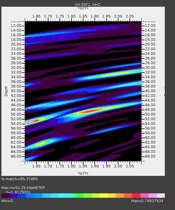
| Estimated Moho Depth: |
53.25 km |
| Estimated Crust Vp/Vs: |
1.61 |
| Assumed Crust Vp: |
6.232 km/s |
| Estimated Crust Vs: |
3.865 km/s |
| Estimated Crust Poisson's Ratio: |
0.19 |
|
| Radial Match: |
95.37495 % |
| Radial Bump: |
340 |
| Transverse Match: |
87.45676 % |
| Transverse Bump: |
400 |
| SOD ConfigId: |
29823551 |
| Insert Time: |
2023-02-20 10:49:05.237 +0000 |
| GWidth: |
2.5 |
| Max Bumps: |
400 |
| Tol: |
0.001 |
|

Signal To Noise
| Channel | StoN | STA | LTA |
| OH:SSF2: :HHZ:20230206T10:36:58.219975Z | 10.350236 | 4.7632907E-6 | 4.6021083E-7 |
| OH:SSF2: :HHN:20230206T10:36:58.219975Z | 2.226108 | 9.630214E-7 | 4.3260317E-7 |
| OH:SSF2: :HHE:20230206T10:36:58.219975Z | 4.4354415 | 1.8499762E-6 | 4.1708955E-7 |
| Arrivals |
| Ps | 5.4 SECOND |
| PpPs | 22 SECOND |
| PsPs/PpSs | 27 SECOND |


