You are here: Home > Network List > OK - Oklahoma Seismic Network Stations List
> Station QUOK Quay, Oklahoma > Earthquake Result Viewer
QUOK Quay, Oklahoma - Earthquake Result Viewer
| Earthquake location: |
Turkey |
| Earthquake latitude/longitude: |
38.0/37.2 |
| Earthquake time(UTC): |
2023/02/06 (037) 10:24:49 GMT |
| Earthquake Depth: |
10 km |
| Earthquake Magnitude: |
7.5 mww |
| Earthquake Catalog/Contributor: |
NEIC PDE/us |
|
| Network: |
OK Oklahoma Seismic Network |
| Station: |
QUOK Quay, Oklahoma |
| Lat/Lon: |
36.17 N/96.71 W |
| Elevation: |
296 m |
|
| Distance: |
94.7 deg |
| Az: |
324.202 deg |
| Baz: |
34.814 deg |
| Ray Param: |
0.040970128 |
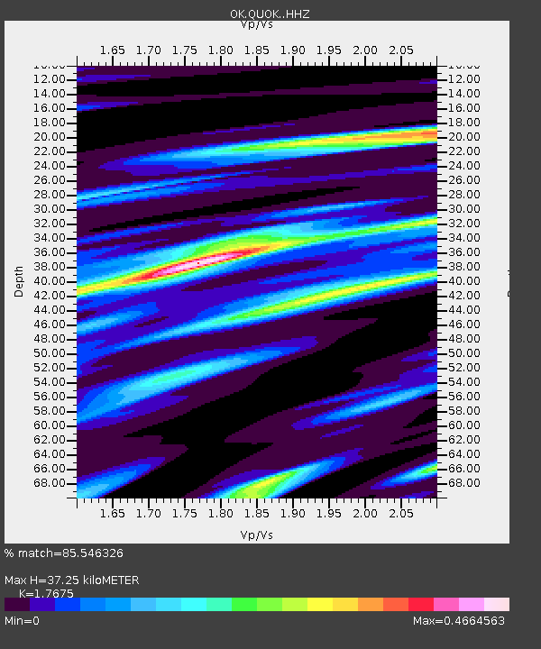
| Estimated Moho Depth: |
37.25 km |
| Estimated Crust Vp/Vs: |
1.77 |
| Assumed Crust Vp: |
6.483 km/s |
| Estimated Crust Vs: |
3.668 km/s |
| Estimated Crust Poisson's Ratio: |
0.26 |
|
| Radial Match: |
85.546326 % |
| Radial Bump: |
400 |
| Transverse Match: |
85.59829 % |
| Transverse Bump: |
400 |
| SOD ConfigId: |
29823551 |
| Insert Time: |
2023-02-20 10:49:25.176 +0000 |
| GWidth: |
2.5 |
| Max Bumps: |
400 |
| Tol: |
0.001 |
|

Signal To Noise
| Channel | StoN | STA | LTA |
| OK:QUOK: :HHZ:20230206T10:37:39.09998Z | 3.070585 | 2.6932023E-6 | 8.770974E-7 |
| OK:QUOK: :HHN:20230206T10:37:39.09998Z | 1.7283095 | 1.2300059E-6 | 7.1168154E-7 |
| OK:QUOK: :HHE:20230206T10:37:39.09998Z | 0.8060348 | 1.0021926E-7 | 1.2433615E-7 |
| Arrivals |
| Ps | 4.5 SECOND |
| PpPs | 16 SECOND |
| PsPs/PpSs | 20 SECOND |


