You are here: Home > Network List > PQ - Public Safety Geoscience Program Canadian Research Network (PSGP) Stations List
> Station ULUN Ulukhaktok, Victoria Island, NWT, Canada > Earthquake Result Viewer
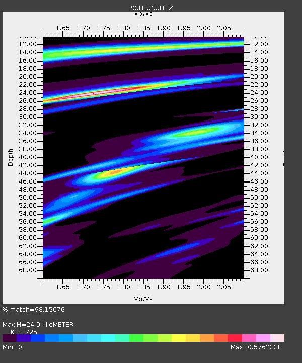
ULUN Ulukhaktok, Victoria Island, NWT, Canada - Earthquake Result Viewer
| Earthquake location: |
Turkey |
| Earthquake latitude/longitude: |
38.0/37.2 |
| Earthquake time(UTC): |
2023/02/06 (037) 10:24:49 GMT |
| Earthquake Depth: |
10 km |
| Earthquake Magnitude: |
7.5 mww |
| Earthquake Catalog/Contributor: |
NEIC PDE/us |
|
| Network: |
PQ Public Safety Geoscience Program Canadian Research Network (PSGP) |
| Station: |
ULUN Ulukhaktok, Victoria Island, NWT, Canada |
| Lat/Lon: |
70.74 N/117.76 W |
| Elevation: |
5.0 m |
|
| Distance: |
70.1 deg |
| Az: |
351.407 deg |
| Baz: |
20.826 deg |
| Ray Param: |
0.05525314 |
| Estimated Moho Depth: |
24.0 km |
| Estimated Crust Vp/Vs: |
1.73 |
| Assumed Crust Vp: |
6.367 km/s |
| Estimated Crust Vs: |
3.691 km/s |
| Estimated Crust Poisson's Ratio: |
0.25 |
|
| Radial Match: |
98.15076 % |
| Radial Bump: |
211 |
| Transverse Match: |
81.84935 % |
| Transverse Bump: |
400 |
| SOD ConfigId: |
29823551 |
| Insert Time: |
2023-02-20 10:50:27.885 +0000 |
| GWidth: |
2.5 |
| Max Bumps: |
400 |
| Tol: |
0.001 |
|

Signal To Noise
| Channel | StoN | STA | LTA |
| PQ:ULUN: :HHZ:20230206T10:35:30.020024Z | 12.749311 | 2.3793777E-6 | 1.8662794E-7 |
| PQ:ULUN: :HHN:20230206T10:35:30.020024Z | 5.245196 | 8.7378464E-7 | 1.6658761E-7 |
| PQ:ULUN: :HHE:20230206T10:35:30.020024Z | 1.2703146 | 3.481521E-7 | 2.7406765E-7 |
| Arrivals |
| Ps | 2.8 SECOND |
| PpPs | 9.9 SECOND |
| PsPs/PpSs | 13 SECOND |


