You are here: Home > Network List > PR - Puerto Rico Seismic Network (PRSN) & Puerto Rico Strong Motion Program (PRSMP) Stations List
> Station CELP Cerrilos Dam > Earthquake Result Viewer
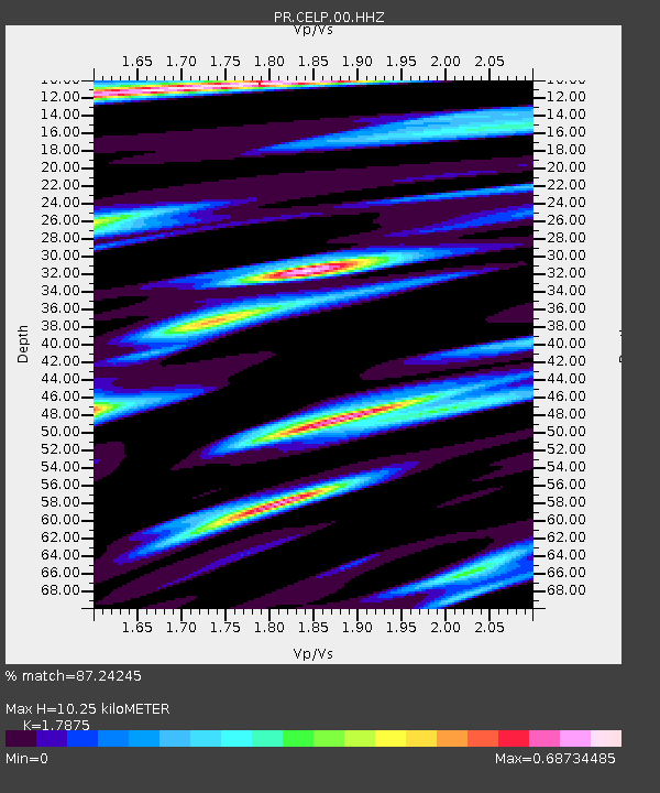
CELP Cerrilos Dam - Earthquake Result Viewer
| Earthquake location: |
Turkey |
| Earthquake latitude/longitude: |
38.0/37.2 |
| Earthquake time(UTC): |
2023/02/06 (037) 10:24:49 GMT |
| Earthquake Depth: |
10 km |
| Earthquake Magnitude: |
7.5 mww |
| Earthquake Catalog/Contributor: |
NEIC PDE/us |
|
| Network: |
PR Puerto Rico Seismic Network (PRSN) & Puerto Rico Strong Motion Program (PRSMP) |
| Station: |
CELP Cerrilos Dam |
| Lat/Lon: |
18.07 N/66.58 W |
| Elevation: |
196 m |
|
| Distance: |
89.4 deg |
| Az: |
292.494 deg |
| Baz: |
50.091 deg |
| Ray Param: |
0.041869234 |
| Estimated Moho Depth: |
10.25 km |
| Estimated Crust Vp/Vs: |
1.79 |
| Assumed Crust Vp: |
5.14 km/s |
| Estimated Crust Vs: |
2.876 km/s |
| Estimated Crust Poisson's Ratio: |
0.27 |
|
| Radial Match: |
87.24245 % |
| Radial Bump: |
348 |
| Transverse Match: |
77.30735 % |
| Transverse Bump: |
400 |
| SOD ConfigId: |
29823551 |
| Insert Time: |
2023-02-20 10:50:33.410 +0000 |
| GWidth: |
2.5 |
| Max Bumps: |
400 |
| Tol: |
0.001 |
|

Signal To Noise
| Channel | StoN | STA | LTA |
| PR:CELP:00:HHZ:20230206T10:37:14.570012Z | 16.484697 | 5.11147E-6 | 3.1007363E-7 |
| PR:CELP:00:HH1:20230206T10:37:14.570012Z | 2.6482503 | 1.100827E-6 | 4.156809E-7 |
| PR:CELP:00:HH2:20230206T10:37:14.570012Z | 4.7552342 | 1.5880563E-6 | 3.3395963E-7 |
| Arrivals |
| Ps | 1.6 SECOND |
| PpPs | 5.5 SECOND |
| PsPs/PpSs | 7.1 SECOND |


