You are here: Home > Network List > IU - Global Seismograph Network (GSN - IRIS/USGS) Stations List
> Station PMG Port Moresby, New Guinea > Earthquake Result Viewer
PMG Port Moresby, New Guinea - Earthquake Result Viewer
*The percent match for this event was below the threshold and hence no stack was calculated.
| Earthquake location: |
Tonga Islands |
| Earthquake latitude/longitude: |
-19.4/-173.7 |
| Earthquake time(UTC): |
2018/06/03 (154) 00:48:09 GMT |
| Earthquake Depth: |
10 km |
| Earthquake Magnitude: |
5.6 mb |
| Earthquake Catalog/Contributor: |
NEIC PDE/us |
|
| Network: |
IU Global Seismograph Network (GSN - IRIS/USGS) |
| Station: |
PMG Port Moresby, New Guinea |
| Lat/Lon: |
9.40 S/147.16 E |
| Elevation: |
90 m |
|
| Distance: |
39.1 deg |
| Az: |
279.068 deg |
| Baz: |
109.157 deg |
| Ray Param: |
$rayparam |
*The percent match for this event was below the threshold and hence was not used in the summary stack. |
|
| Radial Match: |
61.465305 % |
| Radial Bump: |
400 |
| Transverse Match: |
51.388958 % |
| Transverse Bump: |
400 |
| SOD ConfigId: |
2973751 |
| Insert Time: |
2018-10-09 13:11:52.065 +0000 |
| GWidth: |
2.5 |
| Max Bumps: |
400 |
| Tol: |
0.001 |
|
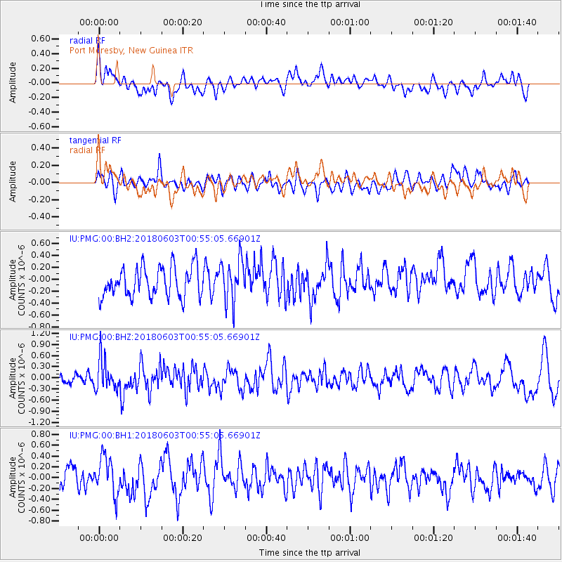
Signal To Noise
| Channel | StoN | STA | LTA |
| IU:PMG:00:BHZ:20180603T00:55:05.66901Z | 2.4012933 | 4.3061664E-7 | 1.7932696E-7 |
| IU:PMG:00:BH1:20180603T00:55:05.66901Z | 2.1583004 | 3.5480224E-7 | 1.6438965E-7 |
| IU:PMG:00:BH2:20180603T00:55:05.66901Z | 1.4370946 | 3.607749E-7 | 2.5104464E-7 |
| Arrivals |
| Ps | |
| PpPs | |
| PsPs/PpSs | |


