You are here: Home > Network List > UW - Pacific Northwest Regional Seismic Network Stations List
> Station HOOD Mt Hood Meadows, OR CREST BB SMO > Earthquake Result Viewer
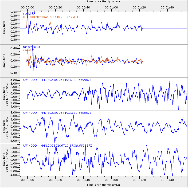
HOOD Mt Hood Meadows, OR CREST BB SMO - Earthquake Result Viewer
*The percent match for this event was below the threshold and hence no stack was calculated.
| Earthquake location: |
Turkey |
| Earthquake latitude/longitude: |
38.0/37.2 |
| Earthquake time(UTC): |
2023/02/06 (037) 10:24:49 GMT |
| Earthquake Depth: |
10 km |
| Earthquake Magnitude: |
7.5 mww |
| Earthquake Catalog/Contributor: |
NEIC PDE/us |
|
| Network: |
UW Pacific Northwest Regional Seismic Network |
| Station: |
HOOD Mt Hood Meadows, OR CREST BB SMO |
| Lat/Lon: |
45.32 N/121.65 W |
| Elevation: |
1520 m |
|
| Distance: |
94.9 deg |
| Az: |
345.202 deg |
| Baz: |
16.613 deg |
| Ray Param: |
$rayparam |
*The percent match for this event was below the threshold and hence was not used in the summary stack. |
|
| Radial Match: |
78.76748 % |
| Radial Bump: |
400 |
| Transverse Match: |
73.871216 % |
| Transverse Bump: |
400 |
| SOD ConfigId: |
29823551 |
| Insert Time: |
2023-02-20 10:56:26.540 +0000 |
| GWidth: |
2.5 |
| Max Bumps: |
400 |
| Tol: |
0.001 |
|
Signal To Noise
| Channel | StoN | STA | LTA |
| UW:HOOD: :HHZ:20230206T10:37:39.669987Z | 2.367399 | 1.384826E-6 | 5.849567E-7 |
| UW:HOOD: :HHN:20230206T10:37:39.669987Z | 1.2882472 | 8.339021E-7 | 6.473153E-7 |
| UW:HOOD: :HHE:20230206T10:37:39.669987Z | 0.609887 | 4.4952517E-7 | 7.3706303E-7 |
| Arrivals |
| Ps | |
| PpPs | |
| PsPs/PpSs | |


