You are here: Home > Network List > UW - Pacific Northwest Regional Seismic Network Stations List
> Station LNO Lincton Mt., Oregon previous ISC code: LNOR > Earthquake Result Viewer
LNO Lincton Mt., Oregon previous ISC code: LNOR - Earthquake Result Viewer
| Earthquake location: |
Turkey |
| Earthquake latitude/longitude: |
38.0/37.2 |
| Earthquake time(UTC): |
2023/02/06 (037) 10:24:49 GMT |
| Earthquake Depth: |
10 km |
| Earthquake Magnitude: |
7.5 mww |
| Earthquake Catalog/Contributor: |
NEIC PDE/us |
|
| Network: |
UW Pacific Northwest Regional Seismic Network |
| Station: |
LNO Lincton Mt., Oregon previous ISC code: LNOR |
| Lat/Lon: |
45.87 N/118.29 W |
| Elevation: |
771 m |
|
| Distance: |
93.6 deg |
| Az: |
343.117 deg |
| Baz: |
19.165 deg |
| Ray Param: |
0.04122855 |
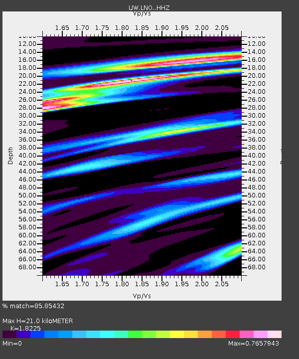
| Estimated Moho Depth: |
21.0 km |
| Estimated Crust Vp/Vs: |
1.82 |
| Assumed Crust Vp: |
6.571 km/s |
| Estimated Crust Vs: |
3.605 km/s |
| Estimated Crust Poisson's Ratio: |
0.28 |
|
| Radial Match: |
85.85432 % |
| Radial Bump: |
400 |
| Transverse Match: |
85.25836 % |
| Transverse Bump: |
353 |
| SOD ConfigId: |
29823551 |
| Insert Time: |
2023-02-20 10:56:57.366 +0000 |
| GWidth: |
2.5 |
| Max Bumps: |
400 |
| Tol: |
0.001 |
|

Signal To Noise
| Channel | StoN | STA | LTA |
| UW:LNO: :HHZ:20230206T10:37:33.979985Z | 4.1312175 | 1.946249E-6 | 4.711079E-7 |
| UW:LNO: :HHN:20230206T10:37:33.979985Z | 1.2534567 | 5.4987527E-7 | 4.386871E-7 |
| UW:LNO: :HHE:20230206T10:37:33.979985Z | 0.40188596 | 1.8847047E-7 | 4.6896506E-7 |
| Arrivals |
| Ps | 2.7 SECOND |
| PpPs | 8.8 SECOND |
| PsPs/PpSs | 12 SECOND |


