You are here: Home > Network List > GO - National Seismic Network of Georgia Stations List
> Station ONI Oni > Earthquake Result Viewer
ONI Oni - Earthquake Result Viewer

| Earthquake location: |
Southwest Of Sumatra, Indonesia |
| Earthquake latitude/longitude: |
-2.1/98.5 |
| Earthquake time(UTC): |
2018/06/12 (163) 23:08:28 GMT |
| Earthquake Depth: |
10 km |
| Earthquake Magnitude: |
5.8 Mww |
| Earthquake Catalog/Contributor: |
NEIC PDE/us |
|
| Network: |
GO National Seismic Network of Georgia |
| Station: |
ONI Oni |
| Lat/Lon: |
42.59 N/43.45 E |
| Elevation: |
810 m |
|
| Distance: |
66.5 deg |
| Az: |
318.704 deg |
| Baz: |
116.737 deg |
| Ray Param: |
0.057545807 |
| Estimated Moho Depth: |
14.0 km |
| Estimated Crust Vp/Vs: |
1.90 |
| Assumed Crust Vp: |
6.247 km/s |
| Estimated Crust Vs: |
3.288 km/s |
| Estimated Crust Poisson's Ratio: |
0.31 |
|
| Radial Match: |
91.41243 % |
| Radial Bump: |
400 |
| Transverse Match: |
88.47942 % |
| Transverse Bump: |
400 |
| SOD ConfigId: |
2973751 |
| Insert Time: |
2018-10-09 13:20:46.735 +0000 |
| GWidth: |
2.5 |
| Max Bumps: |
400 |
| Tol: |
0.001 |
|
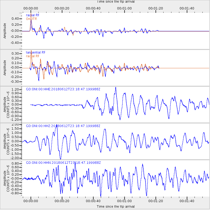
Signal To Noise
| Channel | StoN | STA | LTA |
| GO:ONI:00:HHZ:20180612T23:18:47.199988Z | 4.515601 | 2.7368677E-7 | 6.060915E-8 |
| GO:ONI:00:HHN:20180612T23:18:47.199988Z | 1.4987259 | 6.421729E-8 | 4.284792E-8 |
| GO:ONI:00:HHE:20180612T23:18:47.199988Z | 4.321757 | 1.04711475E-7 | 2.4228912E-8 |
| Arrivals |
| Ps | 2.1 SECOND |
| PpPs | 6.3 SECOND |
| PsPs/PpSs | 8.4 SECOND |


