You are here: Home > Network List > UW - Pacific Northwest Regional Seismic Network Stations List
> Station SKOKO Rock Peak, WA, USA > Earthquake Result Viewer
SKOKO Rock Peak, WA, USA - Earthquake Result Viewer
| Earthquake location: |
Turkey |
| Earthquake latitude/longitude: |
38.0/37.2 |
| Earthquake time(UTC): |
2023/02/06 (037) 10:24:49 GMT |
| Earthquake Depth: |
10 km |
| Earthquake Magnitude: |
7.5 mww |
| Earthquake Catalog/Contributor: |
NEIC PDE/us |
|
| Network: |
UW Pacific Northwest Regional Seismic Network |
| Station: |
SKOKO Rock Peak, WA, USA |
| Lat/Lon: |
47.41 N/123.37 W |
| Elevation: |
950 m |
|
| Distance: |
93.2 deg |
| Az: |
346.921 deg |
| Baz: |
15.256 deg |
| Ray Param: |
0.0413184 |
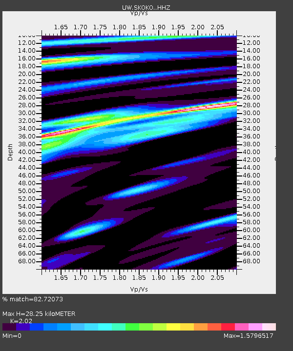
| Estimated Moho Depth: |
28.25 km |
| Estimated Crust Vp/Vs: |
2.02 |
| Assumed Crust Vp: |
6.566 km/s |
| Estimated Crust Vs: |
3.251 km/s |
| Estimated Crust Poisson's Ratio: |
0.34 |
|
| Radial Match: |
82.72073 % |
| Radial Bump: |
400 |
| Transverse Match: |
79.05892 % |
| Transverse Bump: |
400 |
| SOD ConfigId: |
29823551 |
| Insert Time: |
2023-02-20 10:57:50.213 +0000 |
| GWidth: |
2.5 |
| Max Bumps: |
400 |
| Tol: |
0.001 |
|

Signal To Noise
| Channel | StoN | STA | LTA |
| UW:SKOKO: :HHZ:20230206T10:37:32.000004Z | 2.5426998 | 1.6390577E-6 | 6.446132E-7 |
| UW:SKOKO: :HHN:20230206T10:37:32.000004Z | 0.9341249 | 5.70021E-7 | 6.102192E-7 |
| UW:SKOKO: :HHE:20230206T10:37:32.000004Z | 0.86973757 | 7.2066643E-7 | 8.2860214E-7 |
| Arrivals |
| Ps | 4.5 SECOND |
| PpPs | 13 SECOND |
| PsPs/PpSs | 17 SECOND |


