You are here: Home > Network List > N4 - Central and EAstern US Network Stations List
> Station R49A Shelbyville, KY, USA > Earthquake Result Viewer
R49A Shelbyville, KY, USA - Earthquake Result Viewer
| Earthquake location: |
Turkey |
| Earthquake latitude/longitude: |
38.1/38.1 |
| Earthquake time(UTC): |
2023/02/06 (037) 10:51:30 GMT |
| Earthquake Depth: |
12 km |
| Earthquake Magnitude: |
5.7 mb |
| Earthquake Catalog/Contributor: |
NEIC PDE/us |
|
| Network: |
N4 Central and EAstern US Network |
| Station: |
R49A Shelbyville, KY, USA |
| Lat/Lon: |
38.29 N/85.17 W |
| Elevation: |
251 m |
|
| Distance: |
87.7 deg |
| Az: |
318.794 deg |
| Baz: |
41.321 deg |
| Ray Param: |
0.043099377 |
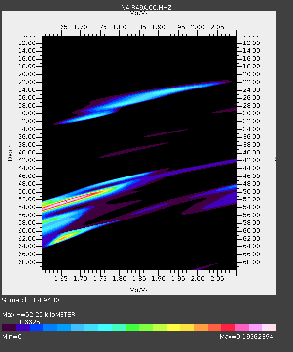
| Estimated Moho Depth: |
52.25 km |
| Estimated Crust Vp/Vs: |
1.66 |
| Assumed Crust Vp: |
6.498 km/s |
| Estimated Crust Vs: |
3.908 km/s |
| Estimated Crust Poisson's Ratio: |
0.22 |
|
| Radial Match: |
84.94301 % |
| Radial Bump: |
400 |
| Transverse Match: |
70.57136 % |
| Transverse Bump: |
302 |
| SOD ConfigId: |
29823551 |
| Insert Time: |
2023-02-20 11:50:11.472 +0000 |
| GWidth: |
2.5 |
| Max Bumps: |
400 |
| Tol: |
0.001 |
|

Signal To Noise
| Channel | StoN | STA | LTA |
| N4:R49A:00:HHZ:20230206T11:03:47.978987Z | 0.582505 | 9.340127E-6 | 1.6034415E-5 |
| N4:R49A:00:HH1:20230206T11:03:47.978987Z | 2.7200804 | 2.9878955E-5 | 1.0984585E-5 |
| N4:R49A:00:HH2:20230206T11:03:47.978987Z | 5.2767425 | 4.7078523E-5 | 8.921892E-6 |
| Arrivals |
| Ps | 5.5 SECOND |
| PpPs | 21 SECOND |
| PsPs/PpSs | 26 SECOND |


