You are here: Home > Network List > N4 - Central and EAstern US Network Stations List
> Station X58A Rowland, NC, USA > Earthquake Result Viewer
X58A Rowland, NC, USA - Earthquake Result Viewer
| Earthquake location: |
Turkey |
| Earthquake latitude/longitude: |
38.1/36.5 |
| Earthquake time(UTC): |
2023/02/06 (037) 12:02:11 GMT |
| Earthquake Depth: |
10 km |
| Earthquake Magnitude: |
6.0 mb |
| Earthquake Catalog/Contributor: |
NEIC PDE/us |
|
| Network: |
N4 Central and EAstern US Network |
| Station: |
X58A Rowland, NC, USA |
| Lat/Lon: |
34.55 N/79.34 W |
| Elevation: |
45 m |
|
| Distance: |
86.4 deg |
| Az: |
311.922 deg |
| Baz: |
45.366 deg |
| Ray Param: |
0.044060018 |
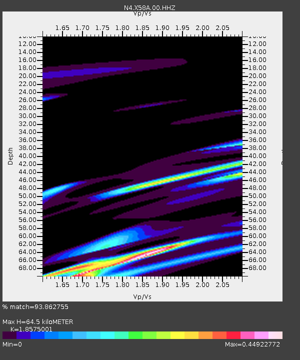
| Estimated Moho Depth: |
64.5 km |
| Estimated Crust Vp/Vs: |
1.86 |
| Assumed Crust Vp: |
6.565 km/s |
| Estimated Crust Vs: |
3.534 km/s |
| Estimated Crust Poisson's Ratio: |
0.30 |
|
| Radial Match: |
93.862755 % |
| Radial Bump: |
381 |
| Transverse Match: |
60.919754 % |
| Transverse Bump: |
400 |
| SOD ConfigId: |
29823551 |
| Insert Time: |
2023-02-20 12:13:51.625 +0000 |
| GWidth: |
2.5 |
| Max Bumps: |
400 |
| Tol: |
0.001 |
|

Signal To Noise
| Channel | StoN | STA | LTA |
| N4:X58A:00:HHZ:20230206T12:14:22.879993Z | 2.4872518 | 8.844504E-6 | 3.5559344E-6 |
| N4:X58A:00:HH1:20230206T12:14:22.879993Z | 0.8094791 | 2.3246205E-6 | 2.8717486E-6 |
| N4:X58A:00:HH2:20230206T12:14:22.879993Z | 1.030037 | 1.4963384E-6 | 1.4527036E-6 |
| Arrivals |
| Ps | 8.6 SECOND |
| PpPs | 27 SECOND |
| PsPs/PpSs | 36 SECOND |


