You are here: Home > Network List > US - United States National Seismic Network Stations List
> Station MSO Missoula, Montana, USA > Earthquake Result Viewer
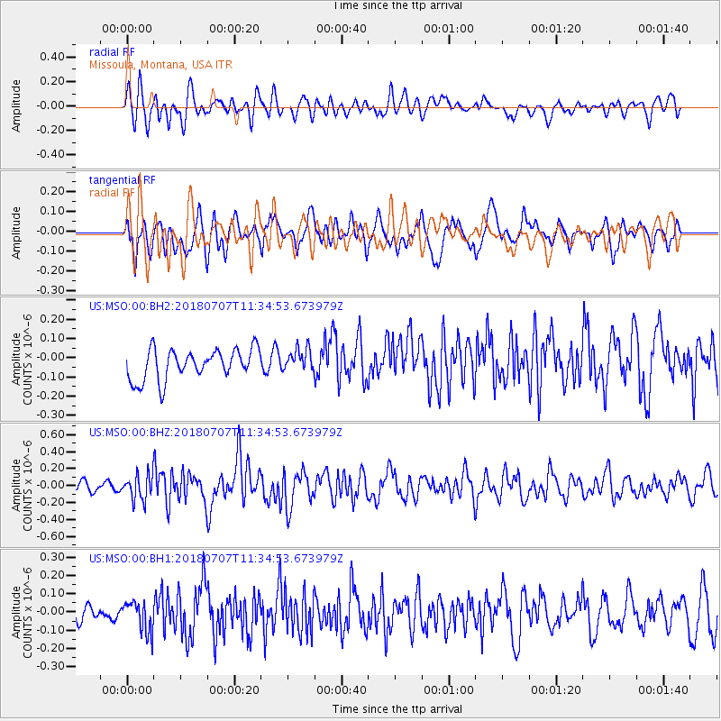
MSO Missoula, Montana, USA - Earthquake Result Viewer
*The percent match for this event was below the threshold and hence no stack was calculated.
| Earthquake location: |
Near East Coast Of Honshu, Japan |
| Earthquake latitude/longitude: |
35.1/140.7 |
| Earthquake time(UTC): |
2018/07/07 (188) 11:23:49 GMT |
| Earthquake Depth: |
39 km |
| Earthquake Magnitude: |
5.9 Mww |
| Earthquake Catalog/Contributor: |
NEIC PDE/us |
|
| Network: |
US United States National Seismic Network |
| Station: |
MSO Missoula, Montana, USA |
| Lat/Lon: |
46.83 N/113.94 W |
| Elevation: |
1264 m |
|
| Distance: |
74.5 deg |
| Az: |
43.376 deg |
| Baz: |
304.891 deg |
| Ray Param: |
$rayparam |
*The percent match for this event was below the threshold and hence was not used in the summary stack. |
|
| Radial Match: |
65.61239 % |
| Radial Bump: |
400 |
| Transverse Match: |
56.015533 % |
| Transverse Bump: |
400 |
| SOD ConfigId: |
2973751 |
| Insert Time: |
2018-10-09 14:45:27.507 +0000 |
| GWidth: |
2.5 |
| Max Bumps: |
400 |
| Tol: |
0.001 |
|
Signal To Noise
| Channel | StoN | STA | LTA |
| US:MSO:00:BHZ:20180707T11:34:53.673979Z | 2.4948165 | 1.5051094E-7 | 6.032946E-8 |
| US:MSO:00:BH1:20180707T11:34:53.673979Z | 1.496884 | 8.345274E-8 | 5.5750974E-8 |
| US:MSO:00:BH2:20180707T11:34:53.673979Z | 0.762933 | 6.019446E-8 | 7.889874E-8 |
| Arrivals |
| Ps | |
| PpPs | |
| PsPs/PpSs | |


