You are here: Home > Network List > US - United States National Seismic Network Stations List
> Station MNTX Cornudas Mountains, Texas, USA > Earthquake Result Viewer
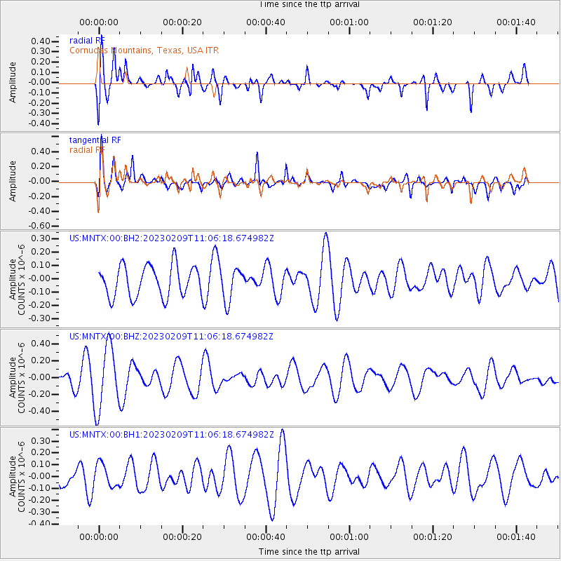
MNTX Cornudas Mountains, Texas, USA - Earthquake Result Viewer
*The percent match for this event was below the threshold and hence no stack was calculated.
| Earthquake location: |
Solomon Islands |
| Earthquake latitude/longitude: |
-10.8/161.6 |
| Earthquake time(UTC): |
2023/02/09 (040) 10:53:17 GMT |
| Earthquake Depth: |
35 km |
| Earthquake Magnitude: |
5.5 Mww |
| Earthquake Catalog/Contributor: |
NEIC PDE/us |
|
| Network: |
US United States National Seismic Network |
| Station: |
MNTX Cornudas Mountains, Texas, USA |
| Lat/Lon: |
31.70 N/105.38 W |
| Elevation: |
405 m |
|
| Distance: |
98.1 deg |
| Az: |
59.291 deg |
| Baz: |
262.367 deg |
| Ray Param: |
$rayparam |
*The percent match for this event was below the threshold and hence was not used in the summary stack. |
|
| Radial Match: |
60.22788 % |
| Radial Bump: |
400 |
| Transverse Match: |
69.854515 % |
| Transverse Bump: |
400 |
| SOD ConfigId: |
29823551 |
| Insert Time: |
2023-02-23 11:06:47.131 +0000 |
| GWidth: |
2.5 |
| Max Bumps: |
400 |
| Tol: |
0.001 |
|
Signal To Noise
| Channel | StoN | STA | LTA |
| US:MNTX:00:BHZ:20230209T11:06:18.674982Z | 2.8741531 | 3.82924E-7 | 1.332302E-7 |
| US:MNTX:00:BH1:20230209T11:06:18.674982Z | 0.977382 | 9.745015E-8 | 9.970528E-8 |
| US:MNTX:00:BH2:20230209T11:06:18.674982Z | 1.0608541 | 1.2373864E-7 | 1.16640585E-7 |
| Arrivals |
| Ps | |
| PpPs | |
| PsPs/PpSs | |


