You are here: Home > Network List > PS - Pacific21 Stations List
> Station JAY Jayapura, Indonesia > Earthquake Result Viewer
JAY Jayapura, Indonesia - Earthquake Result Viewer
| Earthquake location: |
Kermadec Islands, New Zealand |
| Earthquake latitude/longitude: |
-29.5/-178.0 |
| Earthquake time(UTC): |
2023/02/13 (044) 09:18:07 GMT |
| Earthquake Depth: |
374 km |
| Earthquake Magnitude: |
6.1 Mww |
| Earthquake Catalog/Contributor: |
NEIC PDE/us |
|
| Network: |
PS Pacific21 |
| Station: |
JAY Jayapura, Indonesia |
| Lat/Lon: |
2.51 S/140.70 E |
| Elevation: |
439 m |
|
| Distance: |
47.5 deg |
| Az: |
296.564 deg |
| Baz: |
128.711 deg |
| Ray Param: |
0.068387814 |
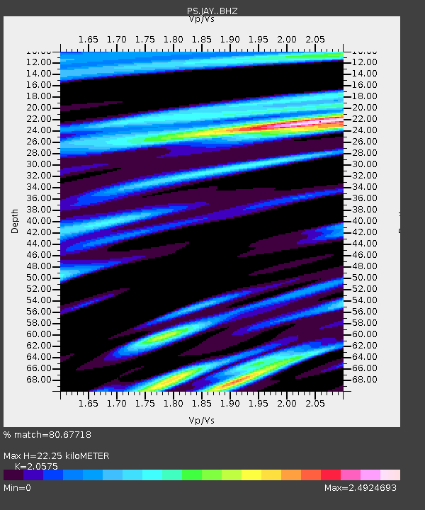
| Estimated Moho Depth: |
22.25 km |
| Estimated Crust Vp/Vs: |
2.06 |
| Assumed Crust Vp: |
6.461 km/s |
| Estimated Crust Vs: |
3.14 km/s |
| Estimated Crust Poisson's Ratio: |
0.35 |
|
| Radial Match: |
80.67718 % |
| Radial Bump: |
400 |
| Transverse Match: |
69.916534 % |
| Transverse Bump: |
400 |
| SOD ConfigId: |
29823551 |
| Insert Time: |
2023-02-27 09:29:40.761 +0000 |
| GWidth: |
2.5 |
| Max Bumps: |
400 |
| Tol: |
0.001 |
|

Signal To Noise
| Channel | StoN | STA | LTA |
| PS:JAY: :BHZ:20230213T09:25:36.610997Z | 14.999362 | 1.3982483E-6 | 9.3220514E-8 |
| PS:JAY: :BHN:20230213T09:25:36.610997Z | 5.321114 | 9.422262E-7 | 1.7707312E-7 |
| PS:JAY: :BHE:20230213T09:25:36.610997Z | 5.8080206 | 8.6039296E-7 | 1.4813875E-7 |
| Arrivals |
| Ps | 3.8 SECOND |
| PpPs | 10 SECOND |
| PsPs/PpSs | 14 SECOND |


