You are here: Home > Network List > US - United States National Seismic Network Stations List
> Station NEW Newport, Washington, USA > Earthquake Result Viewer
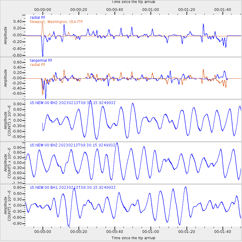
NEW Newport, Washington, USA - Earthquake Result Viewer
*The percent match for this event was below the threshold and hence no stack was calculated.
| Earthquake location: |
Kermadec Islands, New Zealand |
| Earthquake latitude/longitude: |
-29.5/-178.0 |
| Earthquake time(UTC): |
2023/02/13 (044) 09:18:07 GMT |
| Earthquake Depth: |
374 km |
| Earthquake Magnitude: |
6.1 Mww |
| Earthquake Catalog/Contributor: |
NEIC PDE/us |
|
| Network: |
US United States National Seismic Network |
| Station: |
NEW Newport, Washington, USA |
| Lat/Lon: |
48.26 N/117.12 W |
| Elevation: |
760 m |
|
| Distance: |
94.7 deg |
| Az: |
35.839 deg |
| Baz: |
229.794 deg |
| Ray Param: |
$rayparam |
*The percent match for this event was below the threshold and hence was not used in the summary stack. |
|
| Radial Match: |
70.57366 % |
| Radial Bump: |
400 |
| Transverse Match: |
70.71208 % |
| Transverse Bump: |
400 |
| SOD ConfigId: |
29823551 |
| Insert Time: |
2023-02-27 09:32:49.106 +0000 |
| GWidth: |
2.5 |
| Max Bumps: |
400 |
| Tol: |
0.001 |
|
Signal To Noise
| Channel | StoN | STA | LTA |
| US:NEW:00:BHZ:20230213T09:30:15.924993Z | 1.2488487 | 3.2865103E-7 | 2.631632E-7 |
| US:NEW:00:BH1:20230213T09:30:15.924993Z | 0.20352994 | 8.662482E-8 | 4.2561217E-7 |
| US:NEW:00:BH2:20230213T09:30:15.924993Z | 2.035251 | 7.0235956E-7 | 3.4509728E-7 |
| Arrivals |
| Ps | |
| PpPs | |
| PsPs/PpSs | |


