You are here: Home > Network List > IU - Global Seismograph Network (GSN - IRIS/USGS) Stations List
> Station CTAO Charters Towers, Australia > Earthquake Result Viewer
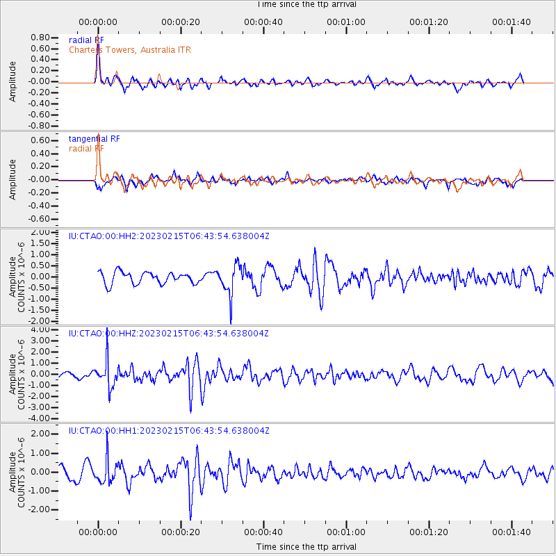
CTAO Charters Towers, Australia - Earthquake Result Viewer
*The percent match for this event was below the threshold and hence no stack was calculated.
| Earthquake location: |
Cook Strait, New Zealand |
| Earthquake latitude/longitude: |
-40.5/174.6 |
| Earthquake time(UTC): |
2023/02/15 (046) 06:38:09 GMT |
| Earthquake Depth: |
74 km |
| Earthquake Magnitude: |
5.7 mww |
| Earthquake Catalog/Contributor: |
NEIC PDE/us |
|
| Network: |
IU Global Seismograph Network (GSN - IRIS/USGS) |
| Station: |
CTAO Charters Towers, Australia |
| Lat/Lon: |
20.09 S/146.25 E |
| Elevation: |
367 m |
|
| Distance: |
31.6 deg |
| Az: |
301.719 deg |
| Baz: |
136.397 deg |
| Ray Param: |
$rayparam |
*The percent match for this event was below the threshold and hence was not used in the summary stack. |
|
| Radial Match: |
74.517876 % |
| Radial Bump: |
400 |
| Transverse Match: |
50.54691 % |
| Transverse Bump: |
400 |
| SOD ConfigId: |
29823551 |
| Insert Time: |
2023-03-01 06:43:28.970 +0000 |
| GWidth: |
2.5 |
| Max Bumps: |
400 |
| Tol: |
0.001 |
|
Signal To Noise
| Channel | StoN | STA | LTA |
| IU:CTAO:00:HHZ:20230215T06:43:54.638004Z | 5.0149956 | 1.2337507E-6 | 2.4601232E-7 |
| IU:CTAO:00:HH1:20230215T06:43:54.638004Z | 2.1832542 | 6.276319E-7 | 2.874754E-7 |
| IU:CTAO:00:HH2:20230215T06:43:54.638004Z | 2.5793152 | 6.82759E-7 | 2.6470553E-7 |
| Arrivals |
| Ps | |
| PpPs | |
| PsPs/PpSs | |


