You are here: Home > Network List > IU - Global Seismograph Network (GSN - IRIS/USGS) Stations List
> Station PMG Port Moresby, New Guinea > Earthquake Result Viewer
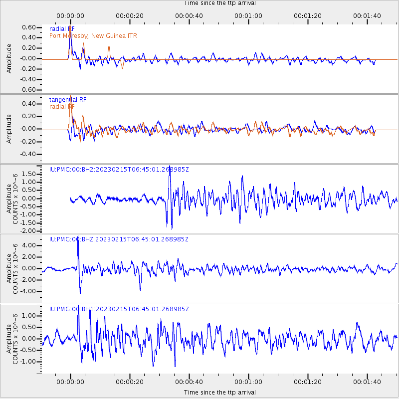
PMG Port Moresby, New Guinea - Earthquake Result Viewer
*The percent match for this event was below the threshold and hence no stack was calculated.
| Earthquake location: |
Cook Strait, New Zealand |
| Earthquake latitude/longitude: |
-40.5/174.6 |
| Earthquake time(UTC): |
2023/02/15 (046) 06:38:09 GMT |
| Earthquake Depth: |
74 km |
| Earthquake Magnitude: |
5.7 mww |
| Earthquake Catalog/Contributor: |
NEIC PDE/us |
|
| Network: |
IU Global Seismograph Network (GSN - IRIS/USGS) |
| Station: |
PMG Port Moresby, New Guinea |
| Lat/Lon: |
9.40 S/147.16 E |
| Elevation: |
90 m |
|
| Distance: |
39.4 deg |
| Az: |
314.313 deg |
| Baz: |
146.455 deg |
| Ray Param: |
$rayparam |
*The percent match for this event was below the threshold and hence was not used in the summary stack. |
|
| Radial Match: |
75.49601 % |
| Radial Bump: |
400 |
| Transverse Match: |
62.323612 % |
| Transverse Bump: |
400 |
| SOD ConfigId: |
29823551 |
| Insert Time: |
2023-03-01 06:43:36.229 +0000 |
| GWidth: |
2.5 |
| Max Bumps: |
400 |
| Tol: |
0.001 |
|
Signal To Noise
| Channel | StoN | STA | LTA |
| IU:PMG:00:BHZ:20230215T06:45:01.268985Z | 7.8325667 | 1.7952221E-6 | 2.2919971E-7 |
| IU:PMG:00:BH1:20230215T06:45:01.268985Z | 2.341227 | 4.6436045E-7 | 1.9834064E-7 |
| IU:PMG:00:BH2:20230215T06:45:01.268985Z | 6.35805 | 8.055082E-7 | 1.2669108E-7 |
| Arrivals |
| Ps | |
| PpPs | |
| PsPs/PpSs | |


