You are here: Home > Network List > G - GEOSCOPE Stations List
> Station ATD Arta Cave - Arta, Republic of Djibouti > Earthquake Result Viewer
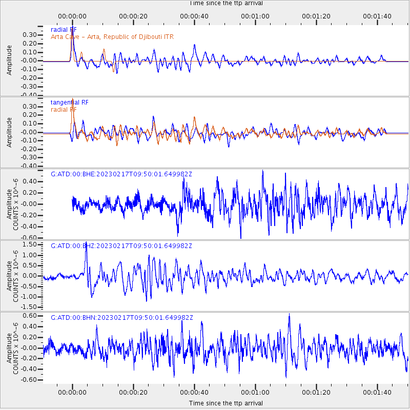
ATD Arta Cave - Arta, Republic of Djibouti - Earthquake Result Viewer
*The percent match for this event was below the threshold and hence no stack was calculated.
| Earthquake location: |
Tanimbar Islands Reg., Indonesia |
| Earthquake latitude/longitude: |
-6.6/132.1 |
| Earthquake time(UTC): |
2023/02/17 (048) 09:37:34 GMT |
| Earthquake Depth: |
39 km |
| Earthquake Magnitude: |
6.1 Mww |
| Earthquake Catalog/Contributor: |
NEIC PDE/us |
|
| Network: |
G GEOSCOPE |
| Station: |
ATD Arta Cave - Arta, Republic of Djibouti |
| Lat/Lon: |
11.53 N/42.85 E |
| Elevation: |
610 m |
|
| Distance: |
90.5 deg |
| Az: |
281.468 deg |
| Baz: |
96.577 deg |
| Ray Param: |
$rayparam |
*The percent match for this event was below the threshold and hence was not used in the summary stack. |
|
| Radial Match: |
77.87038 % |
| Radial Bump: |
400 |
| Transverse Match: |
76.47278 % |
| Transverse Bump: |
400 |
| SOD ConfigId: |
29823551 |
| Insert Time: |
2023-03-03 09:42:55.695 +0000 |
| GWidth: |
2.5 |
| Max Bumps: |
400 |
| Tol: |
0.001 |
|
Signal To Noise
| Channel | StoN | STA | LTA |
| G:ATD:00:BHZ:20230217T09:50:01.649982Z | 6.2394443 | 4.782142E-7 | 7.664371E-8 |
| G:ATD:00:BHN:20230217T09:50:01.649982Z | 0.9951592 | 8.708793E-8 | 8.751156E-8 |
| G:ATD:00:BHE:20230217T09:50:01.649982Z | 1.7726716 | 1.5848482E-7 | 8.94045E-8 |
| Arrivals |
| Ps | |
| PpPs | |
| PsPs/PpSs | |


