You are here: Home > Network List > II - Global Seismograph Network (GSN - IRIS/IDA) Stations List
> Station PALK Pallekele, Sri Lanka > Earthquake Result Viewer
PALK Pallekele, Sri Lanka - Earthquake Result Viewer
| Earthquake location: |
Tanimbar Islands Reg., Indonesia |
| Earthquake latitude/longitude: |
-6.6/132.1 |
| Earthquake time(UTC): |
2023/02/17 (048) 09:37:34 GMT |
| Earthquake Depth: |
39 km |
| Earthquake Magnitude: |
6.1 Mww |
| Earthquake Catalog/Contributor: |
NEIC PDE/us |
|
| Network: |
II Global Seismograph Network (GSN - IRIS/IDA) |
| Station: |
PALK Pallekele, Sri Lanka |
| Lat/Lon: |
7.27 N/80.70 E |
| Elevation: |
460 m |
|
| Distance: |
53.1 deg |
| Az: |
284.166 deg |
| Baz: |
103.842 deg |
| Ray Param: |
0.06627911 |
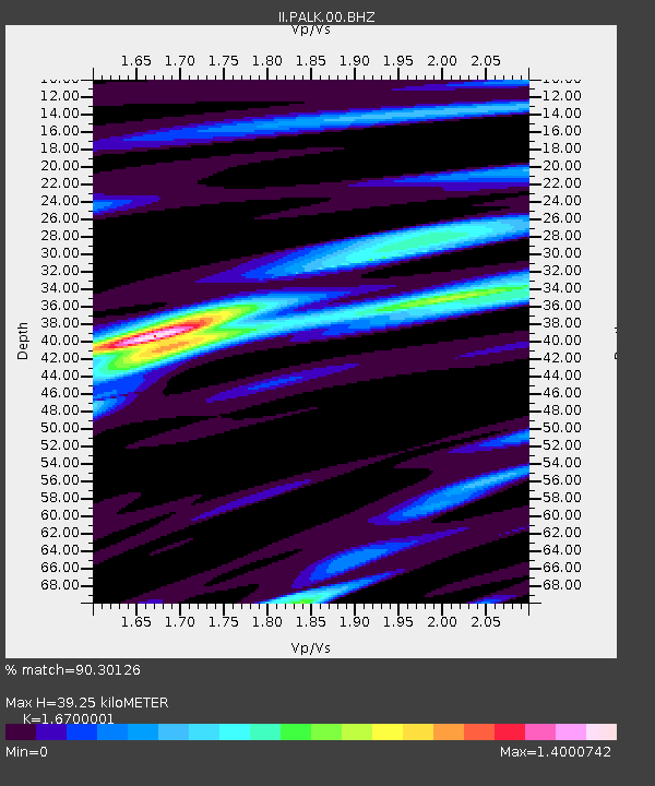
| Estimated Moho Depth: |
39.25 km |
| Estimated Crust Vp/Vs: |
1.67 |
| Assumed Crust Vp: |
6.545 km/s |
| Estimated Crust Vs: |
3.919 km/s |
| Estimated Crust Poisson's Ratio: |
0.22 |
|
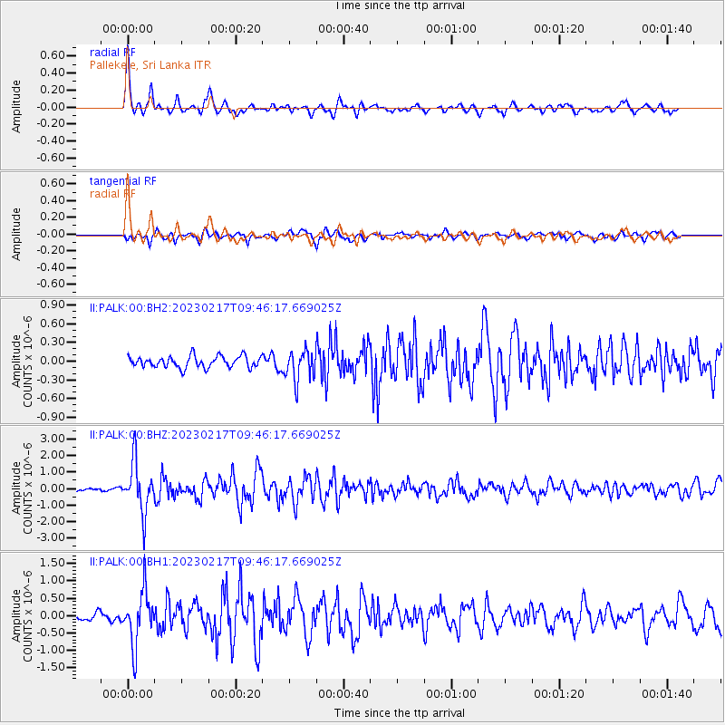
| Radial Match: |
90.30126 % |
| Radial Bump: |
400 |
| Transverse Match: |
82.691185 % |
| Transverse Bump: |
400 |
| SOD ConfigId: |
29823551 |
| Insert Time: |
2023-03-03 09:44:02.786 +0000 |
| GWidth: |
2.5 |
| Max Bumps: |
400 |
| Tol: |
0.001 |
|
Signal To Noise
| Channel | StoN | STA | LTA |
| II:PALK:00:BHZ:20230217T09:46:17.669025Z | 16.480574 | 1.5094759E-6 | 9.1591225E-8 |
| II:PALK:00:BH1:20230217T09:46:17.669025Z | 7.798597 | 7.6900744E-7 | 9.860844E-8 |
| II:PALK:00:BH2:20230217T09:46:17.669025Z | 2.7066941 | 2.4590034E-7 | 9.0848964E-8 |
| Arrivals |
| Ps | 4.3 SECOND |
| PpPs | 15 SECOND |
| PsPs/PpSs | 19 SECOND |


