You are here: Home > Network List > TM - Thai Seismic Monitoring Network Stations List
> Station CMMT CMMT Chiang-Mai Phase1 > Earthquake Result Viewer
CMMT CMMT Chiang-Mai Phase1 - Earthquake Result Viewer
| Earthquake location: |
Tanimbar Islands Reg., Indonesia |
| Earthquake latitude/longitude: |
-6.6/132.1 |
| Earthquake time(UTC): |
2023/02/17 (048) 09:37:34 GMT |
| Earthquake Depth: |
39 km |
| Earthquake Magnitude: |
6.1 Mww |
| Earthquake Catalog/Contributor: |
NEIC PDE/us |
|
| Network: |
TM Thai Seismic Monitoring Network |
| Station: |
CMMT CMMT Chiang-Mai Phase1 |
| Lat/Lon: |
18.81 N/98.94 E |
| Elevation: |
374 m |
|
| Distance: |
41.3 deg |
| Az: |
308.309 deg |
| Baz: |
124.616 deg |
| Ray Param: |
0.07380187 |
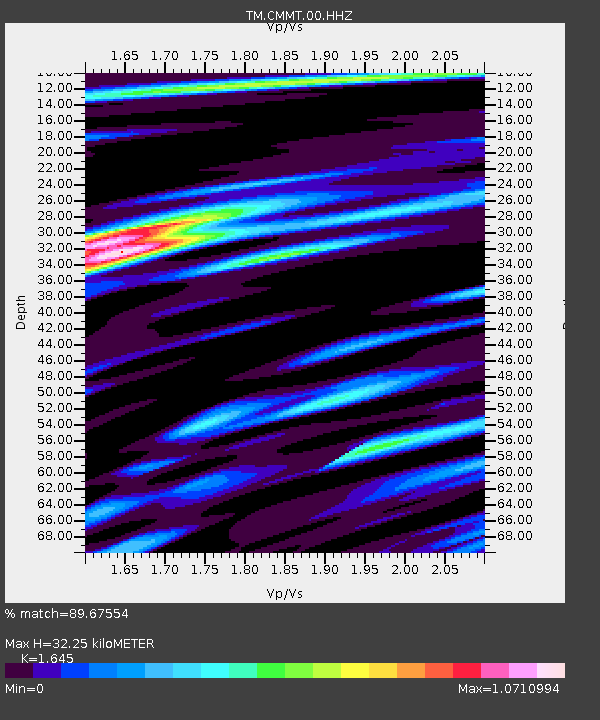
| Estimated Moho Depth: |
32.25 km |
| Estimated Crust Vp/Vs: |
1.64 |
| Assumed Crust Vp: |
6.35 km/s |
| Estimated Crust Vs: |
3.86 km/s |
| Estimated Crust Poisson's Ratio: |
0.21 |
|
| Radial Match: |
89.67554 % |
| Radial Bump: |
400 |
| Transverse Match: |
81.438675 % |
| Transverse Bump: |
400 |
| SOD ConfigId: |
29823551 |
| Insert Time: |
2023-03-03 09:46:56.508 +0000 |
| GWidth: |
2.5 |
| Max Bumps: |
400 |
| Tol: |
0.001 |
|

Signal To Noise
| Channel | StoN | STA | LTA |
| TM:CMMT:00:HHZ:20230217T09:44:46.039997Z | 65.031364 | 5.100477E-6 | 7.8431036E-8 |
| TM:CMMT:00:HHN:20230217T09:44:46.039997Z | 11.564034 | 1.5844525E-6 | 1.3701555E-7 |
| TM:CMMT:00:HHE:20230217T09:44:46.039997Z | 35.411507 | 2.4686076E-6 | 6.9712016E-8 |
| Arrivals |
| Ps | 3.5 SECOND |
| PpPs | 12 SECOND |
| PsPs/PpSs | 16 SECOND |


