You are here: Home > Network List > TM - Thai Seismic Monitoring Network Stations List
> Station NAYO Khun Dan Dam, Nakhon Nayok > Earthquake Result Viewer
NAYO Khun Dan Dam, Nakhon Nayok - Earthquake Result Viewer
| Earthquake location: |
Tanimbar Islands Reg., Indonesia |
| Earthquake latitude/longitude: |
-6.6/132.1 |
| Earthquake time(UTC): |
2023/02/17 (048) 09:37:34 GMT |
| Earthquake Depth: |
39 km |
| Earthquake Magnitude: |
6.1 Mww |
| Earthquake Catalog/Contributor: |
NEIC PDE/us |
|
| Network: |
TM Thai Seismic Monitoring Network |
| Station: |
NAYO Khun Dan Dam, Nakhon Nayok |
| Lat/Lon: |
14.32 N/101.32 E |
| Elevation: |
106 m |
|
| Distance: |
36.9 deg |
| Az: |
304.382 deg |
| Baz: |
122.24 deg |
| Ray Param: |
0.076362014 |
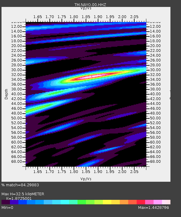
| Estimated Moho Depth: |
32.5 km |
| Estimated Crust Vp/Vs: |
1.87 |
| Assumed Crust Vp: |
6.498 km/s |
| Estimated Crust Vs: |
3.47 km/s |
| Estimated Crust Poisson's Ratio: |
0.30 |
|
| Radial Match: |
84.29883 % |
| Radial Bump: |
306 |
| Transverse Match: |
56.870235 % |
| Transverse Bump: |
400 |
| SOD ConfigId: |
29823551 |
| Insert Time: |
2023-03-03 09:47:00.665 +0000 |
| GWidth: |
2.5 |
| Max Bumps: |
400 |
| Tol: |
0.001 |
|

Signal To Noise
| Channel | StoN | STA | LTA |
| TM:NAYO:00:HHZ:20230217T09:44:09.610004Z | 19.401743 | 2.763894E-6 | 1.4245596E-7 |
| TM:NAYO:00:HHN:20230217T09:44:09.610004Z | 8.617017 | 9.71679E-7 | 1.1276281E-7 |
| TM:NAYO:00:HHE:20230217T09:44:09.610004Z | 9.213346 | 1.4629298E-6 | 1.5878378E-7 |
| Arrivals |
| Ps | 4.7 SECOND |
| PpPs | 13 SECOND |
| PsPs/PpSs | 18 SECOND |


