You are here: Home > Network List > TM - Thai Seismic Monitoring Network Stations List
> Station PBKT Khao Kho, Phetchabun > Earthquake Result Viewer
PBKT Khao Kho, Phetchabun - Earthquake Result Viewer
| Earthquake location: |
Tanimbar Islands Reg., Indonesia |
| Earthquake latitude/longitude: |
-6.6/132.1 |
| Earthquake time(UTC): |
2023/02/17 (048) 09:37:34 GMT |
| Earthquake Depth: |
39 km |
| Earthquake Magnitude: |
6.1 Mww |
| Earthquake Catalog/Contributor: |
NEIC PDE/us |
|
| Network: |
TM Thai Seismic Monitoring Network |
| Station: |
PBKT Khao Kho, Phetchabun |
| Lat/Lon: |
16.57 N/100.97 E |
| Elevation: |
803 m |
|
| Distance: |
38.4 deg |
| Az: |
307.148 deg |
| Baz: |
124.337 deg |
| Ray Param: |
0.075509526 |
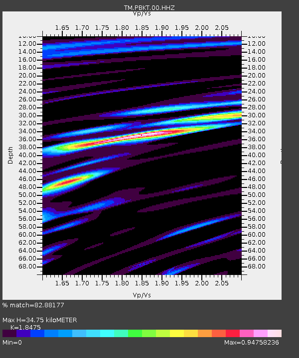
| Estimated Moho Depth: |
34.75 km |
| Estimated Crust Vp/Vs: |
1.85 |
| Assumed Crust Vp: |
6.35 km/s |
| Estimated Crust Vs: |
3.437 km/s |
| Estimated Crust Poisson's Ratio: |
0.29 |
|
| Radial Match: |
82.88177 % |
| Radial Bump: |
400 |
| Transverse Match: |
69.56701 % |
| Transverse Bump: |
400 |
| SOD ConfigId: |
29823551 |
| Insert Time: |
2023-03-03 09:47:03.853 +0000 |
| GWidth: |
2.5 |
| Max Bumps: |
400 |
| Tol: |
0.001 |
|

Signal To Noise
| Channel | StoN | STA | LTA |
| TM:PBKT:00:HHZ:20230217T09:44:22.400013Z | 21.877459 | 2.385408E-6 | 1.09034964E-7 |
| TM:PBKT:00:HHN:20230217T09:44:22.400013Z | 4.300773 | 7.195511E-7 | 1.6730739E-7 |
| TM:PBKT:00:HHE:20230217T09:44:22.400013Z | 15.532381 | 1.615249E-6 | 1.0399236E-7 |
| Arrivals |
| Ps | 5.0 SECOND |
| PpPs | 15 SECOND |
| PsPs/PpSs | 20 SECOND |


