You are here: Home > Network List > TM - Thai Seismic Monitoring Network Stations List
> Station SURA Don Sak, Surat Thani > Earthquake Result Viewer
SURA Don Sak, Surat Thani - Earthquake Result Viewer
| Earthquake location: |
Tanimbar Islands Reg., Indonesia |
| Earthquake latitude/longitude: |
-6.6/132.1 |
| Earthquake time(UTC): |
2023/02/17 (048) 09:37:34 GMT |
| Earthquake Depth: |
39 km |
| Earthquake Magnitude: |
6.1 Mww |
| Earthquake Catalog/Contributor: |
NEIC PDE/us |
|
| Network: |
TM Thai Seismic Monitoring Network |
| Station: |
SURA Don Sak, Surat Thani |
| Lat/Lon: |
9.17 N/99.63 E |
| Elevation: |
18 m |
|
| Distance: |
35.9 deg |
| Az: |
295.471 deg |
| Baz: |
114.721 deg |
| Ray Param: |
0.07690129 |
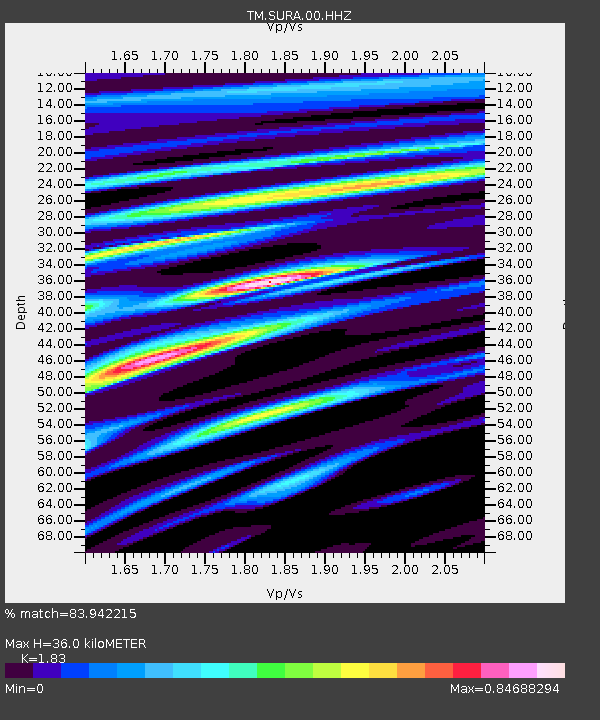
| Estimated Moho Depth: |
36.0 km |
| Estimated Crust Vp/Vs: |
1.83 |
| Assumed Crust Vp: |
6.468 km/s |
| Estimated Crust Vs: |
3.534 km/s |
| Estimated Crust Poisson's Ratio: |
0.29 |
|
| Radial Match: |
83.942215 % |
| Radial Bump: |
372 |
| Transverse Match: |
60.404526 % |
| Transverse Bump: |
400 |
| SOD ConfigId: |
29823551 |
| Insert Time: |
2023-03-03 09:47:13.133 +0000 |
| GWidth: |
2.5 |
| Max Bumps: |
400 |
| Tol: |
0.001 |
|

Signal To Noise
| Channel | StoN | STA | LTA |
| TM:SURA:00:HHZ:20230217T09:44:01.21001Z | 15.826847 | 2.1476164E-6 | 1.3569452E-7 |
| TM:SURA:00:HHN:20230217T09:44:01.21001Z | 2.7627397 | 5.8636766E-7 | 2.1224139E-7 |
| TM:SURA:00:HHE:20230217T09:44:01.21001Z | 5.424826 | 1.0312491E-6 | 1.9009809E-7 |
| Arrivals |
| Ps | 5.0 SECOND |
| PpPs | 15 SECOND |
| PsPs/PpSs | 20 SECOND |


