You are here: Home > Network List > 1E - GSC-BCOGC Induced Seismicity Study Stations List
> Station MONT2 Z > Earthquake Result Viewer
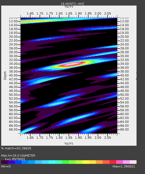
MONT2 Z - Earthquake Result Viewer
| Earthquake location: |
Tajikistan-Xinjiang Border Reg. |
| Earthquake latitude/longitude: |
38.1/73.2 |
| Earthquake time(UTC): |
2023/02/23 (054) 00:37:40 GMT |
| Earthquake Depth: |
21 km |
| Earthquake Magnitude: |
6.8 Mww |
| Earthquake Catalog/Contributor: |
NEIC PDE/us |
|
| Network: |
1E GSC-BCOGC Induced Seismicity Study |
| Station: |
MONT2 Z |
| Lat/Lon: |
56.02 N/120.05 W |
| Elevation: |
642 m |
|
| Distance: |
85.6 deg |
| Az: |
7.419 deg |
| Baz: |
349.543 deg |
| Ray Param: |
0.044635504 |
| Estimated Moho Depth: |
34.0 km |
| Estimated Crust Vp/Vs: |
1.86 |
| Assumed Crust Vp: |
6.291 km/s |
| Estimated Crust Vs: |
3.387 km/s |
| Estimated Crust Poisson's Ratio: |
0.30 |
|
| Radial Match: |
82.26635 % |
| Radial Bump: |
400 |
| Transverse Match: |
66.0834 % |
| Transverse Bump: |
400 |
| SOD ConfigId: |
29823551 |
| Insert Time: |
2023-03-09 00:38:01.274 +0000 |
| GWidth: |
2.5 |
| Max Bumps: |
400 |
| Tol: |
0.001 |
|

Signal To Noise
| Channel | StoN | STA | LTA |
| 1E:MONT2: :HHZ:20230223T00:49:45.750027Z | 9.348867 | 3.5693117E-6 | 3.817908E-7 |
| 1E:MONT2: :HHN:20230223T00:49:45.750027Z | 2.3511395 | 1.5333121E-6 | 6.5215704E-7 |
| 1E:MONT2: :HHE:20230223T00:49:45.750027Z | 0.65213853 | 3.9586982E-7 | 6.070333E-7 |
| Arrivals |
| Ps | 4.7 SECOND |
| PpPs | 15 SECOND |
| PsPs/PpSs | 20 SECOND |


