You are here: Home > Network List > 1E - GSC-BCOGC Induced Seismicity Study Stations List
> Station MONT7 Z > Earthquake Result Viewer
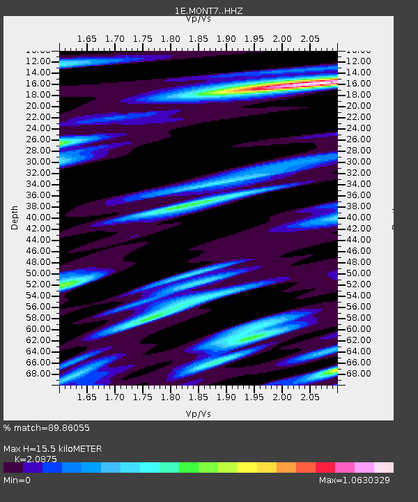
MONT7 Z - Earthquake Result Viewer
| Earthquake location: |
Tajikistan-Xinjiang Border Reg. |
| Earthquake latitude/longitude: |
38.1/73.2 |
| Earthquake time(UTC): |
2023/02/23 (054) 00:37:40 GMT |
| Earthquake Depth: |
21 km |
| Earthquake Magnitude: |
6.8 Mww |
| Earthquake Catalog/Contributor: |
NEIC PDE/us |
|
| Network: |
1E GSC-BCOGC Induced Seismicity Study |
| Station: |
MONT7 Z |
| Lat/Lon: |
56.31 N/122.03 W |
| Elevation: |
797 m |
|
| Distance: |
85.1 deg |
| Az: |
8.455 deg |
| Baz: |
347.982 deg |
| Ray Param: |
0.044995945 |
| Estimated Moho Depth: |
15.5 km |
| Estimated Crust Vp/Vs: |
2.09 |
| Assumed Crust Vp: |
6.232 km/s |
| Estimated Crust Vs: |
2.985 km/s |
| Estimated Crust Poisson's Ratio: |
0.35 |
|
| Radial Match: |
89.86055 % |
| Radial Bump: |
400 |
| Transverse Match: |
65.64648 % |
| Transverse Bump: |
400 |
| SOD ConfigId: |
29823551 |
| Insert Time: |
2023-03-09 00:38:08.871 +0000 |
| GWidth: |
2.5 |
| Max Bumps: |
400 |
| Tol: |
0.001 |
|

Signal To Noise
| Channel | StoN | STA | LTA |
| 1E:MONT7: :HHZ:20230223T00:49:43.259976Z | 10.283124 | 4.0327914E-6 | 3.921757E-7 |
| 1E:MONT7: :HHN:20230223T00:49:43.259976Z | 3.7526886 | 1.4568357E-6 | 3.8821116E-7 |
| 1E:MONT7: :HHE:20230223T00:49:43.259976Z | 1.2381787 | 6.478792E-7 | 5.2325174E-7 |
| Arrivals |
| Ps | 2.8 SECOND |
| PpPs | 7.5 SECOND |
| PsPs/PpSs | 10 SECOND |


