You are here: Home > Network List > AK - Alaska Regional Network Stations List
> Station BESE Bessie Mountain > Earthquake Result Viewer
BESE Bessie Mountain - Earthquake Result Viewer
| Earthquake location: |
Tajikistan-Xinjiang Border Reg. |
| Earthquake latitude/longitude: |
38.1/73.2 |
| Earthquake time(UTC): |
2023/02/23 (054) 00:37:40 GMT |
| Earthquake Depth: |
21 km |
| Earthquake Magnitude: |
6.8 Mww |
| Earthquake Catalog/Contributor: |
NEIC PDE/us |
|
| Network: |
AK Alaska Regional Network |
| Station: |
BESE Bessie Mountain |
| Lat/Lon: |
58.58 N/134.85 W |
| Elevation: |
870 m |
|
| Distance: |
80.9 deg |
| Az: |
14.453 deg |
| Baz: |
337.913 deg |
| Ray Param: |
0.047948025 |
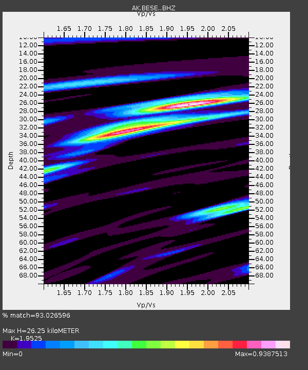
| Estimated Moho Depth: |
26.25 km |
| Estimated Crust Vp/Vs: |
1.95 |
| Assumed Crust Vp: |
6.566 km/s |
| Estimated Crust Vs: |
3.363 km/s |
| Estimated Crust Poisson's Ratio: |
0.32 |
|
| Radial Match: |
93.026596 % |
| Radial Bump: |
400 |
| Transverse Match: |
84.0084 % |
| Transverse Bump: |
400 |
| SOD ConfigId: |
29823551 |
| Insert Time: |
2023-03-09 00:39:12.763 +0000 |
| GWidth: |
2.5 |
| Max Bumps: |
400 |
| Tol: |
0.001 |
|

Signal To Noise
| Channel | StoN | STA | LTA |
| AK:BESE: :BHZ:20230223T00:49:21.607999Z | 9.79245 | 3.2723156E-6 | 3.341672E-7 |
| AK:BESE: :BHN:20230223T00:49:21.607999Z | 4.5921283 | 1.2675649E-6 | 2.7602994E-7 |
| AK:BESE: :BHE:20230223T00:49:21.607999Z | 3.7551043 | 8.1023256E-7 | 2.1576831E-7 |
| Arrivals |
| Ps | 3.9 SECOND |
| PpPs | 11 SECOND |
| PsPs/PpSs | 15 SECOND |


