You are here: Home > Network List > AK - Alaska Regional Network Stations List
> Station N18K Kilae Creek, AK, USA > Earthquake Result Viewer
N18K Kilae Creek, AK, USA - Earthquake Result Viewer
| Earthquake location: |
Tajikistan-Xinjiang Border Reg. |
| Earthquake latitude/longitude: |
38.1/73.2 |
| Earthquake time(UTC): |
2023/02/23 (054) 00:37:40 GMT |
| Earthquake Depth: |
21 km |
| Earthquake Magnitude: |
6.8 Mww |
| Earthquake Catalog/Contributor: |
NEIC PDE/us |
|
| Network: |
AK Alaska Regional Network |
| Station: |
N18K Kilae Creek, AK, USA |
| Lat/Lon: |
60.68 N/155.89 W |
| Elevation: |
572 m |
|
| Distance: |
73.7 deg |
| Az: |
22.801 deg |
| Baz: |
321.58 deg |
| Ray Param: |
0.052796822 |
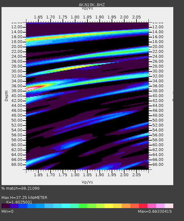
| Estimated Moho Depth: |
37.25 km |
| Estimated Crust Vp/Vs: |
1.60 |
| Assumed Crust Vp: |
6.566 km/s |
| Estimated Crust Vs: |
4.097 km/s |
| Estimated Crust Poisson's Ratio: |
0.18 |
|
| Radial Match: |
89.21098 % |
| Radial Bump: |
400 |
| Transverse Match: |
72.34206 % |
| Transverse Bump: |
400 |
| SOD ConfigId: |
29823551 |
| Insert Time: |
2023-03-09 00:41:28.075 +0000 |
| GWidth: |
2.5 |
| Max Bumps: |
400 |
| Tol: |
0.001 |
|

Signal To Noise
| Channel | StoN | STA | LTA |
| AK:N18K: :BHZ:20230223T00:48:41.579983Z | 10.048591 | 3.456001E-6 | 3.4392892E-7 |
| AK:N18K: :BHN:20230223T00:48:41.579983Z | 4.831815 | 1.1467055E-6 | 2.3732397E-7 |
| AK:N18K: :BHE:20230223T00:48:41.579983Z | 2.569111 | 6.640924E-7 | 2.584911E-7 |
| Arrivals |
| Ps | 3.6 SECOND |
| PpPs | 14 SECOND |
| PsPs/PpSs | 18 SECOND |


