You are here: Home > Network List > AK - Alaska Regional Network Stations List
> Station TGL Tana Glacier > Earthquake Result Viewer
TGL Tana Glacier - Earthquake Result Viewer
| Earthquake location: |
Tajikistan-Xinjiang Border Reg. |
| Earthquake latitude/longitude: |
38.1/73.2 |
| Earthquake time(UTC): |
2023/02/23 (054) 00:37:40 GMT |
| Earthquake Depth: |
21 km |
| Earthquake Magnitude: |
6.8 Mww |
| Earthquake Catalog/Contributor: |
NEIC PDE/us |
|
| Network: |
AK Alaska Regional Network |
| Station: |
TGL Tana Glacier |
| Lat/Lon: |
60.75 N/142.83 W |
| Elevation: |
1260 m |
|
| Distance: |
77.2 deg |
| Az: |
17.232 deg |
| Baz: |
331.567 deg |
| Ray Param: |
0.050465167 |
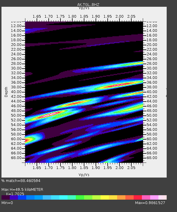
| Estimated Moho Depth: |
49.5 km |
| Estimated Crust Vp/Vs: |
1.70 |
| Assumed Crust Vp: |
6.566 km/s |
| Estimated Crust Vs: |
3.857 km/s |
| Estimated Crust Poisson's Ratio: |
0.24 |
|
| Radial Match: |
88.460594 % |
| Radial Bump: |
400 |
| Transverse Match: |
84.78991 % |
| Transverse Bump: |
400 |
| SOD ConfigId: |
29823551 |
| Insert Time: |
2023-03-09 00:42:23.801 +0000 |
| GWidth: |
2.5 |
| Max Bumps: |
400 |
| Tol: |
0.001 |
|

Signal To Noise
| Channel | StoN | STA | LTA |
| AK:TGL: :BHZ:20230223T00:49:01.448025Z | 27.884466 | 3.6408637E-6 | 1.305696E-7 |
| AK:TGL: :BHN:20230223T00:49:01.448025Z | 11.857036 | 2.095124E-6 | 1.766988E-7 |
| AK:TGL: :BHE:20230223T00:49:01.448025Z | 5.5730786 | 8.256345E-7 | 1.4814694E-7 |
| Arrivals |
| Ps | 5.5 SECOND |
| PpPs | 20 SECOND |
| PsPs/PpSs | 25 SECOND |


