You are here: Home > Network List > AK - Alaska Regional Network Stations List
> Station WRH Wood River Hill > Earthquake Result Viewer
WRH Wood River Hill - Earthquake Result Viewer
| Earthquake location: |
Tajikistan-Xinjiang Border Reg. |
| Earthquake latitude/longitude: |
38.1/73.2 |
| Earthquake time(UTC): |
2023/02/23 (054) 00:37:40 GMT |
| Earthquake Depth: |
21 km |
| Earthquake Magnitude: |
6.8 Mww |
| Earthquake Catalog/Contributor: |
NEIC PDE/us |
|
| Network: |
AK Alaska Regional Network |
| Station: |
WRH Wood River Hill |
| Lat/Lon: |
64.47 N/148.09 W |
| Elevation: |
343 m |
|
| Distance: |
72.8 deg |
| Az: |
17.424 deg |
| Baz: |
326.949 deg |
| Ray Param: |
0.053446103 |
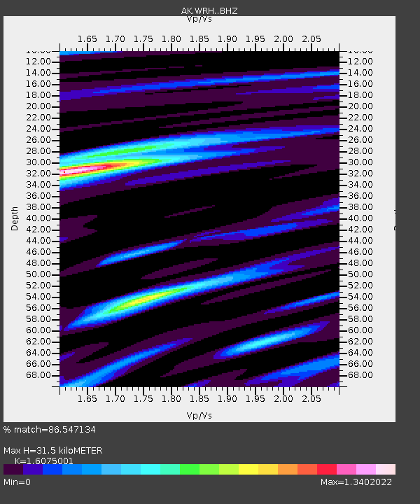
| Estimated Moho Depth: |
31.5 km |
| Estimated Crust Vp/Vs: |
1.61 |
| Assumed Crust Vp: |
6.566 km/s |
| Estimated Crust Vs: |
4.085 km/s |
| Estimated Crust Poisson's Ratio: |
0.18 |
|
| Radial Match: |
86.547134 % |
| Radial Bump: |
400 |
| Transverse Match: |
63.45309 % |
| Transverse Bump: |
400 |
| SOD ConfigId: |
29823551 |
| Insert Time: |
2023-03-09 00:42:41.050 +0000 |
| GWidth: |
2.5 |
| Max Bumps: |
400 |
| Tol: |
0.001 |
|

Signal To Noise
| Channel | StoN | STA | LTA |
| AK:WRH: :BHZ:20230223T00:48:35.847989Z | 18.44307 | 3.7420202E-6 | 2.0289573E-7 |
| AK:WRH: :BHN:20230223T00:48:35.847989Z | 5.9751577 | 1.004427E-6 | 1.6810048E-7 |
| AK:WRH: :BHE:20230223T00:48:35.847989Z | 5.19003 | 8.1288084E-7 | 1.5662353E-7 |
| Arrivals |
| Ps | 3.0 SECOND |
| PpPs | 12 SECOND |
| PsPs/PpSs | 15 SECOND |


