You are here: Home > Network List > AV - Alaska Volcano Observatory Stations List
> Station ILNE Iliamna Northeast, Iliamna, Alaska > Earthquake Result Viewer
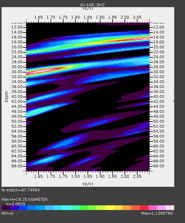
ILNE Iliamna Northeast, Iliamna, Alaska - Earthquake Result Viewer
| Earthquake location: |
Tajikistan-Xinjiang Border Reg. |
| Earthquake latitude/longitude: |
38.1/73.2 |
| Earthquake time(UTC): |
2023/02/23 (054) 00:37:40 GMT |
| Earthquake Depth: |
21 km |
| Earthquake Magnitude: |
6.8 Mww |
| Earthquake Catalog/Contributor: |
NEIC PDE/us |
|
| Network: |
AV Alaska Volcano Observatory |
| Station: |
ILNE Iliamna Northeast, Iliamna, Alaska |
| Lat/Lon: |
60.06 N/153.06 W |
| Elevation: |
1614 m |
|
| Distance: |
75.1 deg |
| Az: |
22.034 deg |
| Baz: |
323.827 deg |
| Ray Param: |
0.05189306 |
| Estimated Moho Depth: |
16.25 km |
| Estimated Crust Vp/Vs: |
2.09 |
| Assumed Crust Vp: |
6.566 km/s |
| Estimated Crust Vs: |
3.138 km/s |
| Estimated Crust Poisson's Ratio: |
0.35 |
|
| Radial Match: |
87.74954 % |
| Radial Bump: |
400 |
| Transverse Match: |
85.14152 % |
| Transverse Bump: |
400 |
| SOD ConfigId: |
29823551 |
| Insert Time: |
2023-03-09 00:45:01.351 +0000 |
| GWidth: |
2.5 |
| Max Bumps: |
400 |
| Tol: |
0.001 |
|

Signal To Noise
| Channel | StoN | STA | LTA |
| AV:ILNE: :BHZ:20230223T00:48:49.399014Z | 17.208944 | 2.7921153E-6 | 1.6224791E-7 |
| AV:ILNE: :BHN:20230223T00:48:49.399014Z | 5.2692504 | 1.1190637E-6 | 2.1237625E-7 |
| AV:ILNE: :BHE:20230223T00:48:49.399014Z | 2.6640716 | 3.8896496E-7 | 1.4600394E-7 |
| Arrivals |
| Ps | 2.8 SECOND |
| PpPs | 7.4 SECOND |
| PsPs/PpSs | 10 SECOND |


