You are here: Home > Network List > AV - Alaska Volcano Observatory Stations List
> Station SPNN North Nagishlamina, Mount Spurr, Alaska > Earthquake Result Viewer
SPNN North Nagishlamina, Mount Spurr, Alaska - Earthquake Result Viewer
| Earthquake location: |
Tajikistan-Xinjiang Border Reg. |
| Earthquake latitude/longitude: |
38.1/73.2 |
| Earthquake time(UTC): |
2023/02/23 (054) 00:37:40 GMT |
| Earthquake Depth: |
21 km |
| Earthquake Magnitude: |
6.8 Mww |
| Earthquake Catalog/Contributor: |
NEIC PDE/us |
|
| Network: |
AV Alaska Volcano Observatory |
| Station: |
SPNN North Nagishlamina, Mount Spurr, Alaska |
| Lat/Lon: |
61.37 N/152.70 W |
| Elevation: |
1666 m |
|
| Distance: |
74.1 deg |
| Az: |
21.082 deg |
| Baz: |
323.889 deg |
| Ray Param: |
0.052540775 |
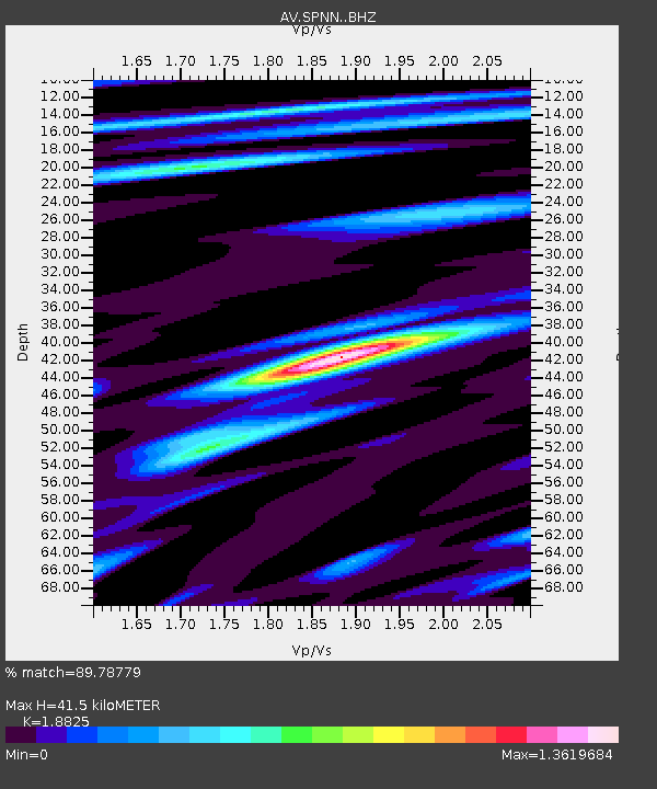
| Estimated Moho Depth: |
41.5 km |
| Estimated Crust Vp/Vs: |
1.88 |
| Assumed Crust Vp: |
6.566 km/s |
| Estimated Crust Vs: |
3.488 km/s |
| Estimated Crust Poisson's Ratio: |
0.30 |
|
| Radial Match: |
89.78779 % |
| Radial Bump: |
400 |
| Transverse Match: |
82.6977 % |
| Transverse Bump: |
400 |
| SOD ConfigId: |
29823551 |
| Insert Time: |
2023-03-09 00:46:21.074 +0000 |
| GWidth: |
2.5 |
| Max Bumps: |
400 |
| Tol: |
0.001 |
|

Signal To Noise
| Channel | StoN | STA | LTA |
| AV:SPNN: :BHZ:20230223T00:48:43.879971Z | 21.539427 | 3.1302586E-6 | 1.4532692E-7 |
| AV:SPNN: :BHN:20230223T00:48:43.879971Z | 6.2348156 | 1.0322512E-6 | 1.6556244E-7 |
| AV:SPNN: :BHE:20230223T00:48:43.879971Z | 3.4215336 | 6.668562E-7 | 1.948998E-7 |
| Arrivals |
| Ps | 5.8 SECOND |
| PpPs | 18 SECOND |
| PsPs/PpSs | 23 SECOND |


