You are here: Home > Network List > G - GEOSCOPE Stations List
> Station TAM Tamanrasset, Algeria > Earthquake Result Viewer
TAM Tamanrasset, Algeria - Earthquake Result Viewer
| Earthquake location: |
Tajikistan-Xinjiang Border Reg. |
| Earthquake latitude/longitude: |
38.1/73.2 |
| Earthquake time(UTC): |
2023/02/23 (054) 00:37:40 GMT |
| Earthquake Depth: |
21 km |
| Earthquake Magnitude: |
6.8 Mww |
| Earthquake Catalog/Contributor: |
NEIC PDE/us |
|
| Network: |
G GEOSCOPE |
| Station: |
TAM Tamanrasset, Algeria |
| Lat/Lon: |
22.79 N/5.53 E |
| Elevation: |
1377 m |
|
| Distance: |
59.1 deg |
| Az: |
275.936 deg |
| Baz: |
58.28 deg |
| Ray Param: |
0.062373366 |
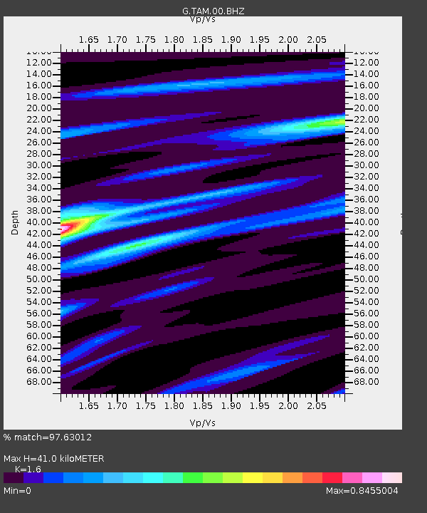
| Estimated Moho Depth: |
41.0 km |
| Estimated Crust Vp/Vs: |
1.60 |
| Assumed Crust Vp: |
6.61 km/s |
| Estimated Crust Vs: |
4.131 km/s |
| Estimated Crust Poisson's Ratio: |
0.18 |
|
| Radial Match: |
97.63012 % |
| Radial Bump: |
155 |
| Transverse Match: |
88.39636 % |
| Transverse Bump: |
386 |
| SOD ConfigId: |
29823551 |
| Insert Time: |
2023-03-09 00:52:19.705 +0000 |
| GWidth: |
2.5 |
| Max Bumps: |
400 |
| Tol: |
0.001 |
|
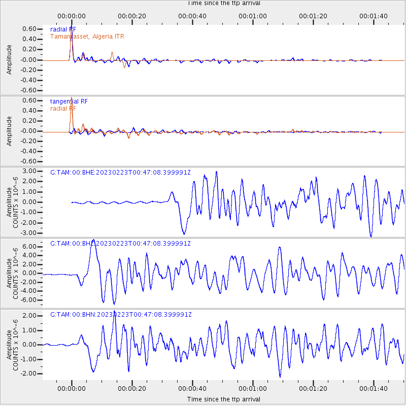
Signal To Noise
| Channel | StoN | STA | LTA |
| G:TAM:00:BHZ:20230223T00:47:08.399991Z | 14.771555 | 1.0881524E-6 | 7.36654E-8 |
| G:TAM:00:BHN:20230223T00:47:08.399991Z | 6.183382 | 2.937696E-7 | 4.7509534E-8 |
| G:TAM:00:BHE:20230223T00:47:08.399991Z | 6.3554893 | 4.432382E-7 | 6.9741006E-8 |
| Arrivals |
| Ps | 3.9 SECOND |
| PpPs | 15 SECOND |
| PsPs/PpSs | 19 SECOND |


