You are here: Home > Network List > JP - Japan Meteorological Agency Seismic Network Stations List
> Station JMN Kochi Monobe > Earthquake Result Viewer
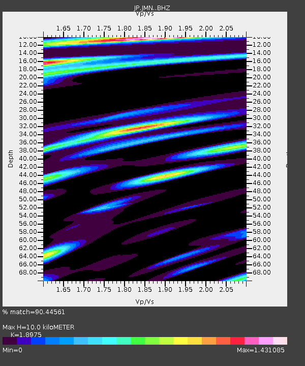
JMN Kochi Monobe - Earthquake Result Viewer
| Earthquake location: |
Tajikistan-Xinjiang Border Reg. |
| Earthquake latitude/longitude: |
38.1/73.2 |
| Earthquake time(UTC): |
2023/02/23 (054) 00:37:40 GMT |
| Earthquake Depth: |
21 km |
| Earthquake Magnitude: |
6.8 Mww |
| Earthquake Catalog/Contributor: |
NEIC PDE/us |
|
| Network: |
JP Japan Meteorological Agency Seismic Network |
| Station: |
JMN Kochi Monobe |
| Lat/Lon: |
33.73 N/133.88 E |
| Elevation: |
550 m |
|
| Distance: |
48.6 deg |
| Az: |
75.674 deg |
| Baz: |
293.423 deg |
| Ray Param: |
0.06924824 |
| Estimated Moho Depth: |
10.0 km |
| Estimated Crust Vp/Vs: |
1.90 |
| Assumed Crust Vp: |
6.468 km/s |
| Estimated Crust Vs: |
3.409 km/s |
| Estimated Crust Poisson's Ratio: |
0.31 |
|
| Radial Match: |
90.44561 % |
| Radial Bump: |
400 |
| Transverse Match: |
83.58531 % |
| Transverse Bump: |
400 |
| SOD ConfigId: |
29823551 |
| Insert Time: |
2023-03-09 00:54:35.668 +0000 |
| GWidth: |
2.5 |
| Max Bumps: |
400 |
| Tol: |
0.001 |
|

Signal To Noise
| Channel | StoN | STA | LTA |
| JP:JMN: :BHZ:20230223T00:45:51.450009Z | 7.85097 | 1.1159676E-6 | 1.4214392E-7 |
| JP:JMN: :BHN:20230223T00:45:51.450009Z | 3.023734 | 4.7345725E-7 | 1.5658033E-7 |
| JP:JMN: :BHE:20230223T00:45:51.450009Z | 2.6624575 | 3.8578838E-7 | 1.4489936E-7 |
| Arrivals |
| Ps | 1.5 SECOND |
| PpPs | 4.2 SECOND |
| PsPs/PpSs | 5.7 SECOND |


