You are here: Home > Network List > PL - Polish Seismological Network Stations List
> Station GKP GORKA KLASZTORNA, POLAND > Earthquake Result Viewer
GKP GORKA KLASZTORNA, POLAND - Earthquake Result Viewer
| Earthquake location: |
Tajikistan-Xinjiang Border Reg. |
| Earthquake latitude/longitude: |
38.1/73.2 |
| Earthquake time(UTC): |
2023/02/23 (054) 00:37:40 GMT |
| Earthquake Depth: |
21 km |
| Earthquake Magnitude: |
6.8 Mww |
| Earthquake Catalog/Contributor: |
NEIC PDE/us |
|
| Network: |
PL Polish Seismological Network |
| Station: |
GKP GORKA KLASZTORNA, POLAND |
| Lat/Lon: |
53.27 N/17.24 E |
| Elevation: |
115 m |
|
| Distance: |
40.9 deg |
| Az: |
310.465 deg |
| Baz: |
88.624 deg |
| Ray Param: |
0.07412067 |
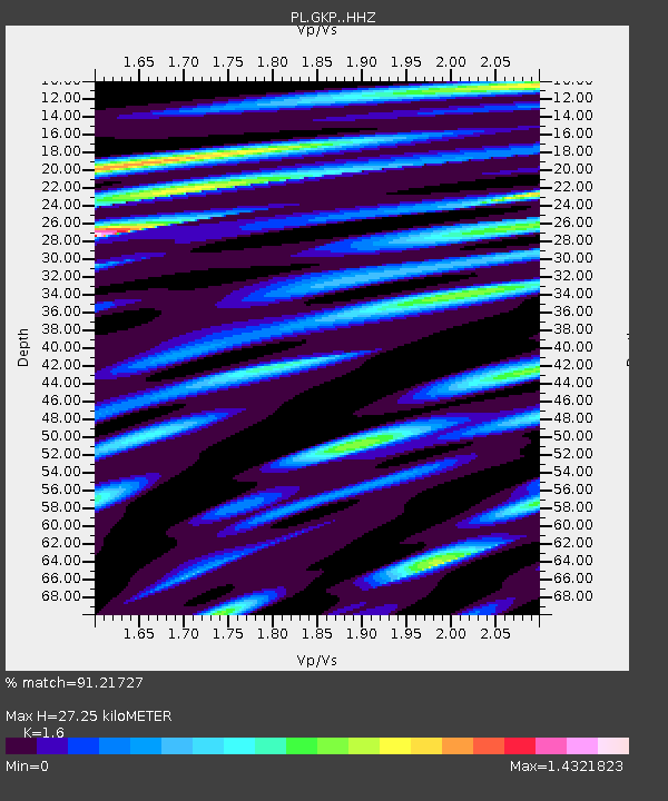
| Estimated Moho Depth: |
27.25 km |
| Estimated Crust Vp/Vs: |
1.60 |
| Assumed Crust Vp: |
6.234 km/s |
| Estimated Crust Vs: |
3.896 km/s |
| Estimated Crust Poisson's Ratio: |
0.18 |
|
| Radial Match: |
91.21727 % |
| Radial Bump: |
400 |
| Transverse Match: |
83.20144 % |
| Transverse Bump: |
400 |
| SOD ConfigId: |
29823551 |
| Insert Time: |
2023-03-09 00:57:36.301 +0000 |
| GWidth: |
2.5 |
| Max Bumps: |
400 |
| Tol: |
0.001 |
|

Signal To Noise
| Channel | StoN | STA | LTA |
| PL:GKP: :HHZ:20230223T00:44:50.019986Z | 19.989342 | 3.3557092E-6 | 1.6787493E-7 |
| PL:GKP: :HHN:20230223T00:44:50.019986Z | 3.5217247 | 7.158613E-7 | 2.0327009E-7 |
| PL:GKP: :HHE:20230223T00:44:50.019986Z | 7.392956 | 1.169668E-6 | 1.5821387E-7 |
| Arrivals |
| Ps | 2.8 SECOND |
| PpPs | 11 SECOND |
| PsPs/PpSs | 13 SECOND |


