You are here: Home > Network List > PL - Polish Seismological Network Stations List
> Station SUW PLSN/GEOFON Station Suwalki, Poland > Earthquake Result Viewer
SUW PLSN/GEOFON Station Suwalki, Poland - Earthquake Result Viewer
| Earthquake location: |
Tajikistan-Xinjiang Border Reg. |
| Earthquake latitude/longitude: |
38.1/73.2 |
| Earthquake time(UTC): |
2023/02/23 (054) 00:37:40 GMT |
| Earthquake Depth: |
21 km |
| Earthquake Magnitude: |
6.8 Mww |
| Earthquake Catalog/Contributor: |
NEIC PDE/us |
|
| Network: |
PL Polish Seismological Network |
| Station: |
SUW PLSN/GEOFON Station Suwalki, Poland |
| Lat/Lon: |
54.01 N/23.18 E |
| Elevation: |
152 m |
|
| Distance: |
37.3 deg |
| Az: |
311.792 deg |
| Baz: |
94.431 deg |
| Ray Param: |
0.07616966 |
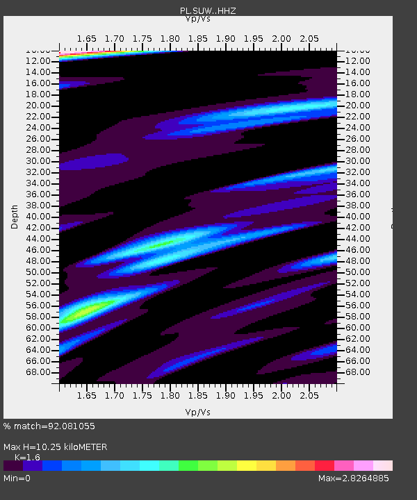
| Estimated Moho Depth: |
10.25 km |
| Estimated Crust Vp/Vs: |
1.60 |
| Assumed Crust Vp: |
6.53 km/s |
| Estimated Crust Vs: |
4.082 km/s |
| Estimated Crust Poisson's Ratio: |
0.18 |
|
| Radial Match: |
92.081055 % |
| Radial Bump: |
339 |
| Transverse Match: |
71.31032 % |
| Transverse Bump: |
400 |
| SOD ConfigId: |
29823551 |
| Insert Time: |
2023-03-09 00:57:43.875 +0000 |
| GWidth: |
2.5 |
| Max Bumps: |
400 |
| Tol: |
0.001 |
|

Signal To Noise
| Channel | StoN | STA | LTA |
| PL:SUW: :HHZ:20230223T00:44:20.656003Z | 21.529963 | 5.921398E-6 | 2.7503057E-7 |
| PL:SUW: :HHN:20230223T00:44:20.656003Z | 1.7759382 | 6.3672286E-7 | 3.5852761E-7 |
| PL:SUW: :HHE:20230223T00:44:20.656003Z | 8.487238 | 5.2609803E-6 | 6.198695E-7 |
| Arrivals |
| Ps | 1.0 SECOND |
| PpPs | 3.7 SECOND |
| PsPs/PpSs | 4.8 SECOND |


