You are here: Home > Network List > US - United States National Seismic Network Stations List
> Station MSO Missoula, Montana, USA > Earthquake Result Viewer
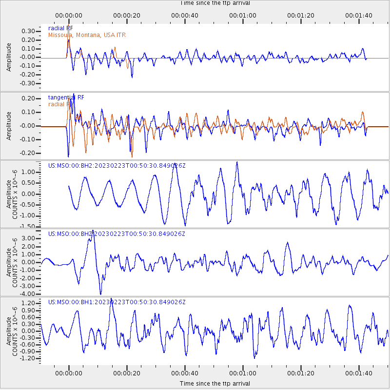
MSO Missoula, Montana, USA - Earthquake Result Viewer
*The percent match for this event was below the threshold and hence no stack was calculated.
| Earthquake location: |
Tajikistan-Xinjiang Border Reg. |
| Earthquake latitude/longitude: |
38.1/73.2 |
| Earthquake time(UTC): |
2023/02/23 (054) 00:37:40 GMT |
| Earthquake Depth: |
21 km |
| Earthquake Magnitude: |
6.8 Mww |
| Earthquake Catalog/Contributor: |
NEIC PDE/us |
|
| Network: |
US United States National Seismic Network |
| Station: |
MSO Missoula, Montana, USA |
| Lat/Lon: |
46.83 N/113.94 W |
| Elevation: |
1264 m |
|
| Distance: |
95.2 deg |
| Az: |
4.922 deg |
| Baz: |
354.34 deg |
| Ray Param: |
$rayparam |
*The percent match for this event was below the threshold and hence was not used in the summary stack. |
|
| Radial Match: |
56.178337 % |
| Radial Bump: |
400 |
| Transverse Match: |
64.04132 % |
| Transverse Bump: |
400 |
| SOD ConfigId: |
29823551 |
| Insert Time: |
2023-03-09 01:01:02.723 +0000 |
| GWidth: |
2.5 |
| Max Bumps: |
400 |
| Tol: |
0.001 |
|
Signal To Noise
| Channel | StoN | STA | LTA |
| US:MSO:00:BHZ:20230223T00:50:30.849026Z | 2.128205 | 1.1338255E-6 | 5.327614E-7 |
| US:MSO:00:BH1:20230223T00:50:30.849026Z | 1.0453937 | 5.2055674E-7 | 4.9795284E-7 |
| US:MSO:00:BH2:20230223T00:50:30.849026Z | 1.9988112 | 8.4357646E-7 | 4.2203908E-7 |
| Arrivals |
| Ps | |
| PpPs | |
| PsPs/PpSs | |


