You are here: Home > Network List > GS - US Geological Survey Networks Stations List
> Station OK052 Battle Ridge Rd, NW of Cushing, OK, USA > Earthquake Result Viewer
OK052 Battle Ridge Rd, NW of Cushing, OK, USA - Earthquake Result Viewer
| Earthquake location: |
Andreanof Islands, Aleutian Is. |
| Earthquake latitude/longitude: |
51.5/-177.9 |
| Earthquake time(UTC): |
2018/08/23 (235) 03:35:15 GMT |
| Earthquake Depth: |
44 km |
| Earthquake Magnitude: |
6.0 Ml |
| Earthquake Catalog/Contributor: |
NEIC PDE/us |
|
| Network: |
GS US Geological Survey Networks |
| Station: |
OK052 Battle Ridge Rd, NW of Cushing, OK, USA |
| Lat/Lon: |
35.99 N/96.80 W |
| Elevation: |
259 m |
|
| Distance: |
57.6 deg |
| Az: |
71.538 deg |
| Baz: |
313.034 deg |
| Ray Param: |
0.06327578 |
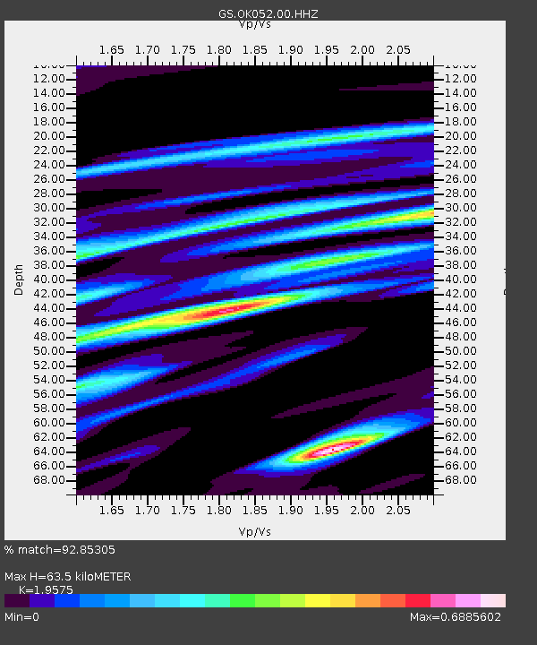
| Estimated Moho Depth: |
63.5 km |
| Estimated Crust Vp/Vs: |
1.96 |
| Assumed Crust Vp: |
6.426 km/s |
| Estimated Crust Vs: |
3.283 km/s |
| Estimated Crust Poisson's Ratio: |
0.32 |
|
| Radial Match: |
92.85305 % |
| Radial Bump: |
394 |
| Transverse Match: |
78.01778 % |
| Transverse Bump: |
400 |
| SOD ConfigId: |
3045211 |
| Insert Time: |
2018-10-09 19:18:35.513 +0000 |
| GWidth: |
2.5 |
| Max Bumps: |
400 |
| Tol: |
0.001 |
|

Signal To Noise
| Channel | StoN | STA | LTA |
| GS:OK052:00:HHZ:20180823T03:44:30.929004Z | 18.195023 | 1.5681888E-6 | 8.618779E-8 |
| GS:OK052:00:HH1:20180823T03:44:30.929004Z | 4.857632 | 6.288684E-7 | 1.2945986E-7 |
| GS:OK052:00:HH2:20180823T03:44:30.929004Z | 4.752731 | 7.4331155E-7 | 1.5639672E-7 |
| Arrivals |
| Ps | 9.9 SECOND |
| PpPs | 28 SECOND |
| PsPs/PpSs | 38 SECOND |


