You are here: Home > Network List > CO - South Carolina Seismic Network Stations List
> Station TEEBA Mateeba, Summerville SC > Earthquake Result Viewer
TEEBA Mateeba, Summerville SC - Earthquake Result Viewer
| Earthquake location: |
Peru-Brazil Border Region |
| Earthquake latitude/longitude: |
-11.0/-70.8 |
| Earthquake time(UTC): |
2018/08/24 (236) 09:04:06 GMT |
| Earthquake Depth: |
609 km |
| Earthquake Magnitude: |
7.1 Mww |
| Earthquake Catalog/Contributor: |
NEIC PDE/us |
|
| Network: |
CO South Carolina Seismic Network |
| Station: |
TEEBA Mateeba, Summerville SC |
| Lat/Lon: |
32.90 N/80.19 W |
| Elevation: |
11 m |
|
| Distance: |
44.6 deg |
| Az: |
348.746 deg |
| Baz: |
166.836 deg |
| Ray Param: |
0.06872685 |
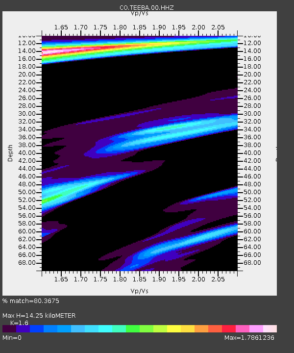
| Estimated Moho Depth: |
14.25 km |
| Estimated Crust Vp/Vs: |
1.60 |
| Assumed Crust Vp: |
6.565 km/s |
| Estimated Crust Vs: |
4.103 km/s |
| Estimated Crust Poisson's Ratio: |
0.18 |
|
| Radial Match: |
80.3675 % |
| Radial Bump: |
280 |
| Transverse Match: |
66.44648 % |
| Transverse Bump: |
373 |
| SOD ConfigId: |
3045211 |
| Insert Time: |
2018-10-09 19:24:02.578 +0000 |
| GWidth: |
2.5 |
| Max Bumps: |
400 |
| Tol: |
0.001 |
|

Signal To Noise
| Channel | StoN | STA | LTA |
| CO:TEEBA:00:HHZ:20180824T09:10:55.847993Z | 70.57283 | 3.1598156E-5 | 4.4773824E-7 |
| CO:TEEBA:00:HH1:20180824T09:10:55.847993Z | 14.598658 | 8.647371E-6 | 5.9234014E-7 |
| CO:TEEBA:00:HH2:20180824T09:10:55.847993Z | 18.350931 | 1.6225878E-5 | 8.8419915E-7 |
| Arrivals |
| Ps | 1.4 SECOND |
| PpPs | 5.3 SECOND |
| PsPs/PpSs | 6.7 SECOND |


