You are here: Home > Network List > AK - Alaska Regional Network Stations List
> Station H16K Elim, AK, USA > Earthquake Result Viewer
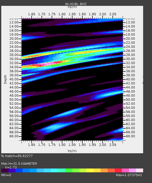
H16K Elim, AK, USA - Earthquake Result Viewer
| Earthquake location: |
North Of Halmahera, Indonesia |
| Earthquake latitude/longitude: |
3.3/128.1 |
| Earthquake time(UTC): |
2023/02/23 (054) 20:02:48 GMT |
| Earthquake Depth: |
97 km |
| Earthquake Magnitude: |
6.3 mww |
| Earthquake Catalog/Contributor: |
NEIC PDE/us |
|
| Network: |
AK Alaska Regional Network |
| Station: |
H16K Elim, AK, USA |
| Lat/Lon: |
64.64 N/162.24 W |
| Elevation: |
216 m |
|
| Distance: |
78.4 deg |
| Az: |
24.342 deg |
| Baz: |
252.833 deg |
| Ray Param: |
0.04948046 |
| Estimated Moho Depth: |
31.5 km |
| Estimated Crust Vp/Vs: |
1.73 |
| Assumed Crust Vp: |
6.276 km/s |
| Estimated Crust Vs: |
3.628 km/s |
| Estimated Crust Poisson's Ratio: |
0.25 |
|
| Radial Match: |
85.92277 % |
| Radial Bump: |
400 |
| Transverse Match: |
63.49741 % |
| Transverse Bump: |
400 |
| SOD ConfigId: |
29823551 |
| Insert Time: |
2023-03-09 20:05:04.067 +0000 |
| GWidth: |
2.5 |
| Max Bumps: |
400 |
| Tol: |
0.001 |
|

Signal To Noise
| Channel | StoN | STA | LTA |
| AK:H16K: :BHZ:20230223T20:14:07.119971Z | 8.475645 | 1.4535101E-6 | 1.7149256E-7 |
| AK:H16K: :BHN:20230223T20:14:07.119971Z | 0.70989484 | 1.6143234E-7 | 2.2740318E-7 |
| AK:H16K: :BHE:20230223T20:14:07.119971Z | 4.179008 | 6.9642385E-7 | 1.6664814E-7 |
| Arrivals |
| Ps | 3.8 SECOND |
| PpPs | 13 SECOND |
| PsPs/PpSs | 17 SECOND |


