You are here: Home > Network List > CN - Canadian National Seismograph Network Stations List
> Station INK INUVIK, NT > Earthquake Result Viewer
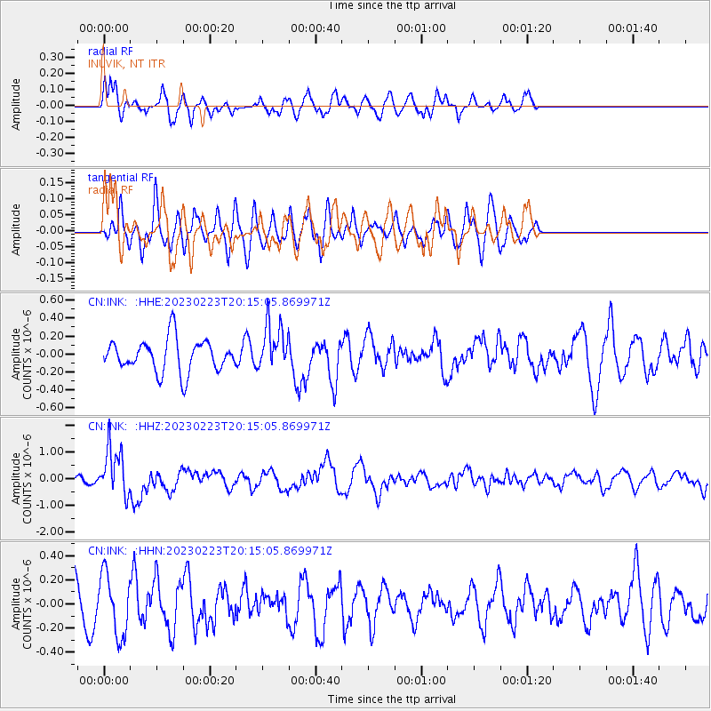
INK INUVIK, NT - Earthquake Result Viewer
*The percent match for this event was below the threshold and hence no stack was calculated.
| Earthquake location: |
North Of Halmahera, Indonesia |
| Earthquake latitude/longitude: |
3.3/128.1 |
| Earthquake time(UTC): |
2023/02/23 (054) 20:02:48 GMT |
| Earthquake Depth: |
97 km |
| Earthquake Magnitude: |
6.3 mww |
| Earthquake Catalog/Contributor: |
NEIC PDE/us |
|
| Network: |
CN Canadian National Seismograph Network |
| Station: |
INK INUVIK, NT |
| Lat/Lon: |
68.31 N/133.53 W |
| Elevation: |
44 m |
|
| Distance: |
90.0 deg |
| Az: |
21.584 deg |
| Baz: |
278.951 deg |
| Ray Param: |
$rayparam |
*The percent match for this event was below the threshold and hence was not used in the summary stack. |
|
| Radial Match: |
68.61387 % |
| Radial Bump: |
400 |
| Transverse Match: |
30.038832 % |
| Transverse Bump: |
363 |
| SOD ConfigId: |
29823551 |
| Insert Time: |
2023-03-09 20:11:40.514 +0000 |
| GWidth: |
2.5 |
| Max Bumps: |
400 |
| Tol: |
0.001 |
|
Signal To Noise
| Channel | StoN | STA | LTA |
| CN:INK: :HHZ:20230223T20:15:05.869971Z | 5.940925 | 8.96235E-7 | 1.5085782E-7 |
| CN:INK: :HHN:20230223T20:15:05.869971Z | 1.1908476 | 2.5375454E-7 | 2.1308732E-7 |
| CN:INK: :HHE:20230223T20:15:05.869971Z | 1.3922786 | 2.5233285E-7 | 1.8123734E-7 |
| Arrivals |
| Ps | |
| PpPs | |
| PsPs/PpSs | |


