You are here: Home > Network List > G - GEOSCOPE Stations List
> Station ATD Arta Cave - Arta, Republic of Djibouti > Earthquake Result Viewer
ATD Arta Cave - Arta, Republic of Djibouti - Earthquake Result Viewer
| Earthquake location: |
North Of Halmahera, Indonesia |
| Earthquake latitude/longitude: |
3.3/128.1 |
| Earthquake time(UTC): |
2023/02/23 (054) 20:02:48 GMT |
| Earthquake Depth: |
97 km |
| Earthquake Magnitude: |
6.3 mww |
| Earthquake Catalog/Contributor: |
NEIC PDE/us |
|
| Network: |
G GEOSCOPE |
| Station: |
ATD Arta Cave - Arta, Republic of Djibouti |
| Lat/Lon: |
11.53 N/42.85 E |
| Elevation: |
610 m |
|
| Distance: |
84.7 deg |
| Az: |
281.214 deg |
| Baz: |
87.686 deg |
| Ray Param: |
0.04505842 |
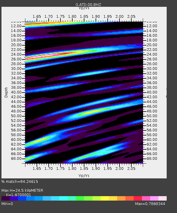
| Estimated Moho Depth: |
24.5 km |
| Estimated Crust Vp/Vs: |
1.67 |
| Assumed Crust Vp: |
6.375 km/s |
| Estimated Crust Vs: |
3.817 km/s |
| Estimated Crust Poisson's Ratio: |
0.22 |
|
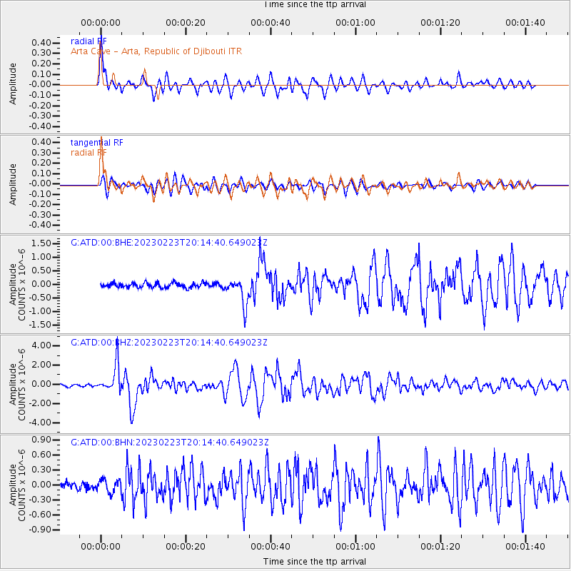
| Radial Match: |
94.24615 % |
| Radial Bump: |
400 |
| Transverse Match: |
84.00087 % |
| Transverse Bump: |
400 |
| SOD ConfigId: |
29823551 |
| Insert Time: |
2023-03-09 20:12:07.878 +0000 |
| GWidth: |
2.5 |
| Max Bumps: |
400 |
| Tol: |
0.001 |
|
Signal To Noise
| Channel | StoN | STA | LTA |
| G:ATD:00:BHZ:20230223T20:14:40.649023Z | 16.254948 | 1.4834761E-6 | 9.126305E-8 |
| G:ATD:00:BHN:20230223T20:14:40.649023Z | 1.6177846 | 1.3070904E-7 | 8.0795076E-8 |
| G:ATD:00:BHE:20230223T20:14:40.649023Z | 5.8345313 | 5.052682E-7 | 8.659962E-8 |
| Arrivals |
| Ps | 2.6 SECOND |
| PpPs | 10 SECOND |
| PsPs/PpSs | 13 SECOND |


