You are here: Home > Network List > MM - Myanmar National Seismic Network Stations List
> Station NGU Ngaung U, Myanmar > Earthquake Result Viewer
NGU Ngaung U, Myanmar - Earthquake Result Viewer
| Earthquake location: |
North Of Halmahera, Indonesia |
| Earthquake latitude/longitude: |
3.3/128.1 |
| Earthquake time(UTC): |
2023/02/23 (054) 20:02:48 GMT |
| Earthquake Depth: |
97 km |
| Earthquake Magnitude: |
6.3 mww |
| Earthquake Catalog/Contributor: |
NEIC PDE/us |
|
| Network: |
MM Myanmar National Seismic Network |
| Station: |
NGU Ngaung U, Myanmar |
| Lat/Lon: |
21.21 N/94.92 E |
| Elevation: |
70 m |
|
| Distance: |
36.9 deg |
| Az: |
301.556 deg |
| Baz: |
114.258 deg |
| Ray Param: |
0.07613916 |
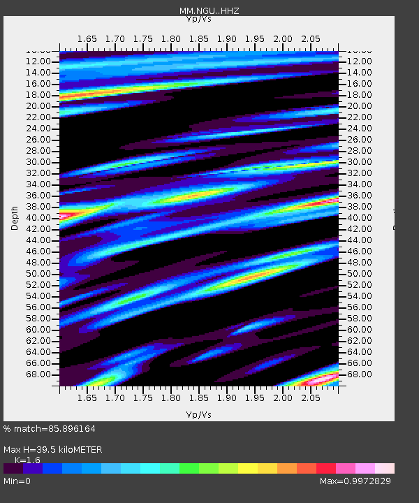
| Estimated Moho Depth: |
39.5 km |
| Estimated Crust Vp/Vs: |
1.60 |
| Assumed Crust Vp: |
6.036 km/s |
| Estimated Crust Vs: |
3.773 km/s |
| Estimated Crust Poisson's Ratio: |
0.18 |
|
| Radial Match: |
85.896164 % |
| Radial Bump: |
400 |
| Transverse Match: |
74.72643 % |
| Transverse Bump: |
400 |
| SOD ConfigId: |
29823551 |
| Insert Time: |
2023-03-09 20:15:25.094 +0000 |
| GWidth: |
2.5 |
| Max Bumps: |
400 |
| Tol: |
0.001 |
|

Signal To Noise
| Channel | StoN | STA | LTA |
| MM:NGU: :HHZ:20230223T20:09:17.16001Z | 59.18114 | 7.557357E-6 | 1.2769874E-7 |
| MM:NGU: :HHN:20230223T20:09:17.16001Z | 8.695541 | 1.0863918E-6 | 1.2493665E-7 |
| MM:NGU: :HHE:20230223T20:09:17.16001Z | 14.795529 | 1.7474265E-6 | 1.18105035E-7 |
| Arrivals |
| Ps | 4.2 SECOND |
| PpPs | 16 SECOND |
| PsPs/PpSs | 20 SECOND |


