You are here: Home > Network List > TM - Thai Seismic Monitoring Network Stations List
> Station CMAI AngKang, ChiangMai > Earthquake Result Viewer
CMAI AngKang, ChiangMai - Earthquake Result Viewer
| Earthquake location: |
North Of Halmahera, Indonesia |
| Earthquake latitude/longitude: |
3.3/128.1 |
| Earthquake time(UTC): |
2023/02/23 (054) 20:02:48 GMT |
| Earthquake Depth: |
97 km |
| Earthquake Magnitude: |
6.3 mww |
| Earthquake Catalog/Contributor: |
NEIC PDE/us |
|
| Network: |
TM Thai Seismic Monitoring Network |
| Station: |
CMAI AngKang, ChiangMai |
| Lat/Lon: |
19.93 N/99.05 E |
| Elevation: |
1544 m |
|
| Distance: |
32.8 deg |
| Az: |
302.451 deg |
| Baz: |
116.436 deg |
| Ray Param: |
0.07822572 |
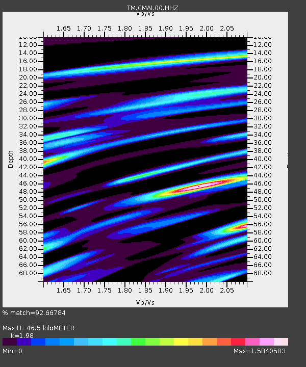
| Estimated Moho Depth: |
46.5 km |
| Estimated Crust Vp/Vs: |
1.98 |
| Assumed Crust Vp: |
6.35 km/s |
| Estimated Crust Vs: |
3.207 km/s |
| Estimated Crust Poisson's Ratio: |
0.33 |
|
| Radial Match: |
92.66784 % |
| Radial Bump: |
339 |
| Transverse Match: |
67.734795 % |
| Transverse Bump: |
400 |
| SOD ConfigId: |
29823551 |
| Insert Time: |
2023-03-09 20:17:05.978 +0000 |
| GWidth: |
2.5 |
| Max Bumps: |
400 |
| Tol: |
0.001 |
|

Signal To Noise
| Channel | StoN | STA | LTA |
| TM:CMAI:00:HHZ:20230223T20:08:42.530005Z | 28.316578 | 2.6014252E-6 | 9.186934E-8 |
| TM:CMAI:00:HHN:20230223T20:08:42.530005Z | 4.6451364 | 1.1202333E-6 | 2.411626E-7 |
| TM:CMAI:00:HHE:20230223T20:08:42.530005Z | 13.299351 | 1.969072E-6 | 1.4805775E-7 |
| Arrivals |
| Ps | 7.7 SECOND |
| PpPs | 20 SECOND |
| PsPs/PpSs | 28 SECOND |


