You are here: Home > Network List > UU - University of Utah Regional Network Stations List
> Station FOR3 Blundell North, UT, USA > Earthquake Result Viewer
FOR3 Blundell North, UT, USA - Earthquake Result Viewer
| Earthquake location: |
Southeast Of Loyalty Islands |
| Earthquake latitude/longitude: |
-22.2/170.0 |
| Earthquake time(UTC): |
2018/08/29 (241) 03:51:55 GMT |
| Earthquake Depth: |
10 km |
| Earthquake Magnitude: |
7.0 Mi |
| Earthquake Catalog/Contributor: |
NEIC PDE/pt |
|
| Network: |
UU University of Utah Regional Network |
| Station: |
FOR3 Blundell North, UT, USA |
| Lat/Lon: |
38.51 N/112.88 W |
| Elevation: |
1699 m |
|
| Distance: |
94.1 deg |
| Az: |
50.064 deg |
| Baz: |
244.941 deg |
| Ray Param: |
0.041128572 |
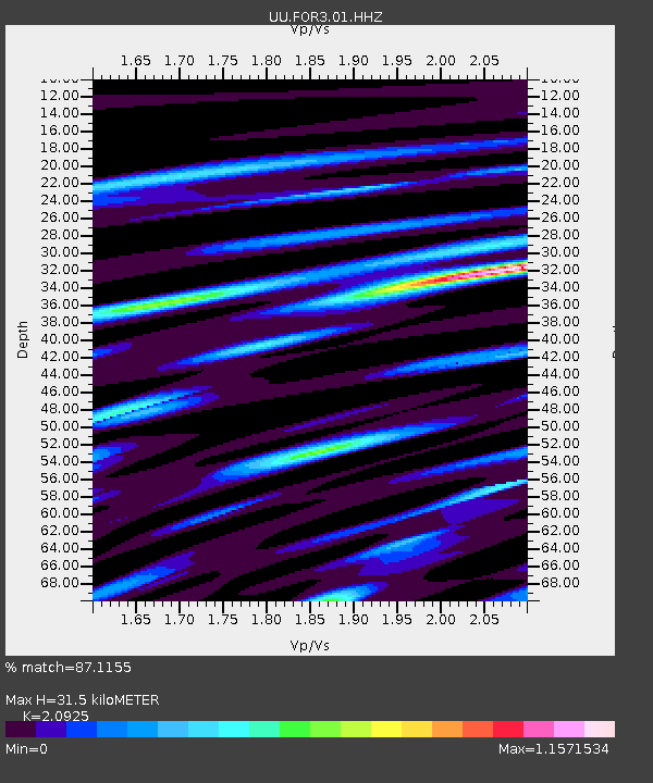
| Estimated Moho Depth: |
31.5 km |
| Estimated Crust Vp/Vs: |
2.09 |
| Assumed Crust Vp: |
6.276 km/s |
| Estimated Crust Vs: |
2.999 km/s |
| Estimated Crust Poisson's Ratio: |
0.35 |
|
| Radial Match: |
87.1155 % |
| Radial Bump: |
400 |
| Transverse Match: |
76.35692 % |
| Transverse Bump: |
400 |
| SOD ConfigId: |
3045211 |
| Insert Time: |
2018-10-09 19:51:50.212 +0000 |
| GWidth: |
2.5 |
| Max Bumps: |
400 |
| Tol: |
0.001 |
|

Signal To Noise
| Channel | StoN | STA | LTA |
| UU:FOR3:01:HHZ:20180829T04:04:40.679993Z | 16.538126 | 2.3198657E-8 | 1.4027379E-9 |
| UU:FOR3:01:HHN:20180829T04:04:40.679993Z | 1.1611519 | 5.8265974E-9 | 5.0179456E-9 |
| UU:FOR3:01:HHE:20180829T04:04:40.679993Z | 2.515869 | 9.264677E-9 | 3.6824959E-9 |
| Arrivals |
| Ps | 5.6 SECOND |
| PpPs | 15 SECOND |
| PsPs/PpSs | 21 SECOND |


