You are here: Home > Network List > AK - Alaska Regional Network Stations List
> Station G24K Hadweenzic River, AK, USA > Earthquake Result Viewer
G24K Hadweenzic River, AK, USA - Earthquake Result Viewer
| Earthquake location: |
Hokkaido, Japan Region |
| Earthquake latitude/longitude: |
42.8/145.1 |
| Earthquake time(UTC): |
2023/02/25 (056) 13:27:42 GMT |
| Earthquake Depth: |
43 km |
| Earthquake Magnitude: |
6.1 Mww |
| Earthquake Catalog/Contributor: |
NEIC PDE/us |
|
| Network: |
AK Alaska Regional Network |
| Station: |
G24K Hadweenzic River, AK, USA |
| Lat/Lon: |
66.70 N/147.48 W |
| Elevation: |
503 m |
|
| Distance: |
42.8 deg |
| Az: |
32.683 deg |
| Baz: |
270.777 deg |
| Ray Param: |
0.07282538 |
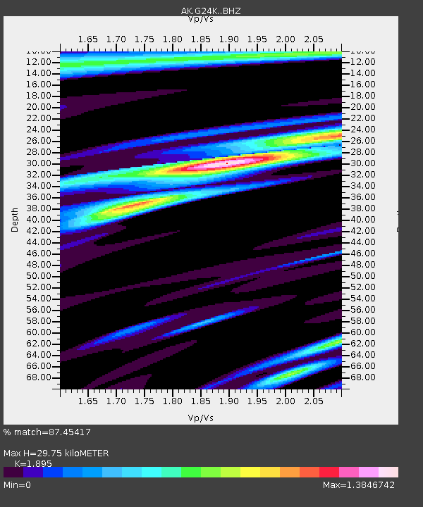
| Estimated Moho Depth: |
29.75 km |
| Estimated Crust Vp/Vs: |
1.89 |
| Assumed Crust Vp: |
6.522 km/s |
| Estimated Crust Vs: |
3.441 km/s |
| Estimated Crust Poisson's Ratio: |
0.31 |
|
| Radial Match: |
87.45417 % |
| Radial Bump: |
398 |
| Transverse Match: |
75.64958 % |
| Transverse Bump: |
400 |
| SOD ConfigId: |
29823551 |
| Insert Time: |
2023-03-11 13:30:52.956 +0000 |
| GWidth: |
2.5 |
| Max Bumps: |
400 |
| Tol: |
0.001 |
|

Signal To Noise
| Channel | StoN | STA | LTA |
| AK:G24K: :BHZ:20230225T13:35:05.680008Z | 24.695992 | 4.4392186E-6 | 1.7975461E-7 |
| AK:G24K: :BHN:20230225T13:35:05.680008Z | 1.3226658 | 3.0129564E-7 | 2.2779423E-7 |
| AK:G24K: :BHE:20230225T13:35:05.680008Z | 8.010569 | 1.7150902E-6 | 2.1410344E-7 |
| Arrivals |
| Ps | 4.4 SECOND |
| PpPs | 12 SECOND |
| PsPs/PpSs | 17 SECOND |


