You are here: Home > Network List > AK - Alaska Regional Network Stations List
> Station H16K Elim, AK, USA > Earthquake Result Viewer
H16K Elim, AK, USA - Earthquake Result Viewer
| Earthquake location: |
Hokkaido, Japan Region |
| Earthquake latitude/longitude: |
42.8/145.1 |
| Earthquake time(UTC): |
2023/02/25 (056) 13:27:42 GMT |
| Earthquake Depth: |
43 km |
| Earthquake Magnitude: |
6.1 Mww |
| Earthquake Catalog/Contributor: |
NEIC PDE/us |
|
| Network: |
AK Alaska Regional Network |
| Station: |
H16K Elim, AK, USA |
| Lat/Lon: |
64.64 N/162.24 W |
| Elevation: |
216 m |
|
| Distance: |
36.6 deg |
| Az: |
35.048 deg |
| Baz: |
259.147 deg |
| Ray Param: |
0.07653199 |
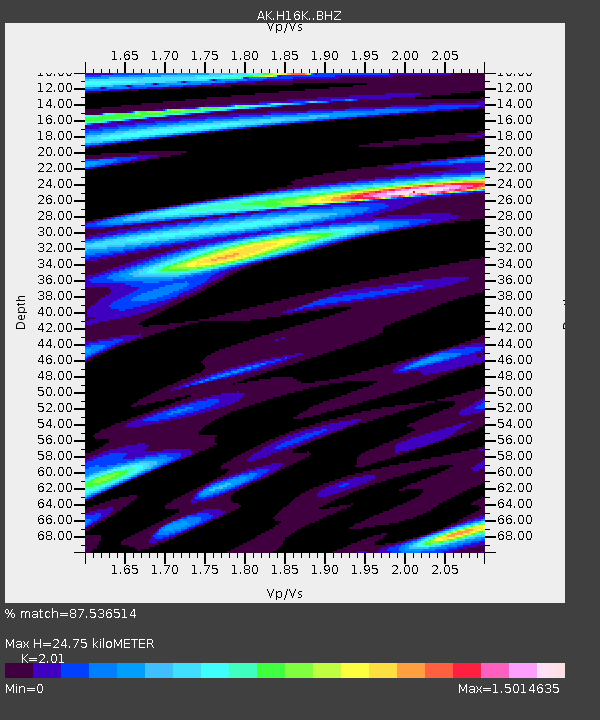
| Estimated Moho Depth: |
24.75 km |
| Estimated Crust Vp/Vs: |
2.01 |
| Assumed Crust Vp: |
6.276 km/s |
| Estimated Crust Vs: |
3.122 km/s |
| Estimated Crust Poisson's Ratio: |
0.34 |
|
| Radial Match: |
87.536514 % |
| Radial Bump: |
353 |
| Transverse Match: |
85.17852 % |
| Transverse Bump: |
400 |
| SOD ConfigId: |
29823551 |
| Insert Time: |
2023-03-11 13:31:03.272 +0000 |
| GWidth: |
2.5 |
| Max Bumps: |
400 |
| Tol: |
0.001 |
|

Signal To Noise
| Channel | StoN | STA | LTA |
| AK:H16K: :BHZ:20230225T13:34:13.740006Z | 18.601814 | 3.5178261E-6 | 1.8911199E-7 |
| AK:H16K: :BHN:20230225T13:34:13.740006Z | 3.8496046 | 3.8947294E-7 | 1.011722E-7 |
| AK:H16K: :BHE:20230225T13:34:13.740006Z | 17.240189 | 2.204347E-6 | 1.2786096E-7 |
| Arrivals |
| Ps | 4.2 SECOND |
| PpPs | 11 SECOND |
| PsPs/PpSs | 15 SECOND |


